Stykkishólmur, Bjarnarhöfn and Ólafsvik
North to Snæfellnes
 |
| Iceland |
After breakfast we drove from our hotel on the tip of the small Borganes peninsula, turned north and after 40 minutes or so reached the
base of the much larger Snæfellsnes peninsula which protrudes some 90km into the North Atlantic. The names of both
locations end in ‘-nes’, meaning a headland or peninsula, like the English ‘ness.’
Fell means hill or mountain as it does in northern England while Snæ derives from an old Norse word for snow. Snaefell
is also the name of the highest point on the Isle of Man.
Snæfellsnesjökull at the tip of the peninsula is a dormant volcano topped with a glacial ice-cap (jökull means ‘glacier’). It was through
this volcano that Professor Otto Lidenbrock started his descent in Jules Verne’s
Journey to the Centre of the Earth.
 |
| Snæfellsnes Peninsula (Snæfellsnesjökull is misspelt on the map) Map by Maximilian Dörrbecker reproduced under CC BY-SA 2.0 |
Baulárvallavatn
We arrived on the above map on Highway 54 and turned right to cross the peninsula on Highway 56 aiming for Stykkishólmur
as our first destination.
 |
| Highway 56 across the Snæfellsnes peninsula |
Halfway across is a small lake called Baulárvallavatn and just beyond is a pull off and viewpoint where it is possible to stand atop basalt columns and block out a small part of the lava-lands behind...
 |
| The viewpoint near Baulárvallavatn |
…but only a small part as they stretch in more than one direction.
 |
| Lava plain near Baulárvallavatn |
Stykkishólmur
 |
| Stykkishólmur |
Earning its living from fishing and tourism, Stykkishólmur is a village with just over 1,000
inhabitants that has spread around its harbour at the tip of a small peninsula
on the north coast of Snaefellsnes.
On a small map the peninsula appears a solid piece of land, but aerial photographs reveal a landscape that looks shattered, with jagged
shards of green land set in a gunmetal sea. In reality it is the volcanic land
which is invading the sea, though the sea fights back in a long, slow war of
attrition. It is not immediately obvious from above that Stykkishólmur
is not on an island but after a straight-line crossing of the flat moor-like
land at the base of the peninsula the small but well-made road loops round several
inlets and finds its way without need of a bridge.
 |
| Stykkishólmur Harbour |
Like most Icelandic villages Stykkishólmur is a loose collection of unlovely buildings, knitted together by far more services than
might be expected in a place of its size.
 |
| Stykkishólmur |
They are, though, particularly proud of the ‘Norwegian House’. Constructed in 1832 it was Iceland’s first wood-frame residence with
two full-sized storeys. That seems very late, but the wood had to be imported
from Norway (hence the name), elsewhere it grow on trees, but not here. It serves as the regional museum, which has mixed reviews, but
we had limited time and another museum we wanted to visit.
 |
| Norwegian House, Stykkishómur |
At 65° 04´ North, Stykkishólmur is the most northerly* point we have ever reached.
Bjarnarhöfn
Bjarnarhöfn, a 20-minute drive from Stykkishólmur, is beside the coast at the end of a minor road off Highway 54. It consists of a church, a farm, maybe two, and a shark museum. This is enough for it to feature on the Snaefellsnes map (above).
 |
| Bjarnarhöfn |
I am no expert, but I doubt that much of a living can be wrung from a few damp fields between the mountains and a cold sea….
 |
| The hay has been cut, Bjarnarhöfn |
…and the ‘museum’ is more a random collection of bits and pieces than a carefully curated exhibition…
 |
| Shark museum, Bjarnarhöfn |
…but that is not what it is really about, though the elaborate tessellation of the floor tiles provides a few minutes distraction. The raison d’être of the shark museum is hakarl.
 |
| Shark museum, Bjarnarhöfn |
Hakarl – Fermented Greenland Shark
Greenland shark have no kidneys and circulate their urine through their bodies as antifreeze. Although this makes their meat poisonous, fishing
for Greenland shark was big business in the 19th century, as their fat produces
large quantities of high-grade oil. In those far off days Greenland sharks lit
the homes of Icelanders in the long winter nights, their lamps little more than
an oil reservoir with an inserted wick.
Once the oil had been extracted, the highly toxic carcass was buried to prevent dogs or farm animals eating them. During one of
Iceland’s occasional famines – harvests were variable and food could not be
imported during winter months when ships did not sail – a starving person
exhumed and then consumed such a shark. They must have been desperate, and were
probably unaware that the fermentation of the corpse had destroyed the toxin. When
they did not die, old Icelanders, firmly of the opinion that what does not kill
you makes you stronger, saw an opportunity.
Abundant cheap hydro and geothermal energy means nobody has fished for Greenland shark for a century or more, but they are occasionally landed after becoming entangled in nets. Such sharks are brough here, their heads and guts removed and they undergo a more modern
and hygienic version of being buried for six to twelve weeks, depending on the
season. The fish is now safe to eat, but contains too much ammonia to be
palatable, so it is cut into strips and hung an open shed at the back of the
farm.
 |
| Walking up to the curing shed, Bjarnarhöfn |
Here fresh air wafts away the ammonia and finishes the curing process.
 |
| Curing Hakarl, Bjarnarhöfn |
After several months dangling in the breeze, it is vacuum packed and sold to punters.
 |
| Vacuum packed hakarl ready for sale, Bjarnarhöfn (750 Is Krona = £4.50 = US $5.80) |
Tasting Hakarl
Two bowls sat on the table in the tasting room. One contained small cubes of hakarl, the other slightly larger (dice-sized) cubes of rye bread.
Wikipedia quotes a list of culinary luminaries, including Gordon Ramsey, Anthony Bourdain and Ainsley Harriott describing the horrors of
Hakarl. We preferred to start from a different position: if the good people of
Iceland think this is fine traditional food, then we should approach it with an
open mind (and mouth).
Lynne skewered cubes of hakarl and rye bread on a cocktail stick (the usual way to eat Hakarl) and had a go…
 |
| Lynne eats hakarl and rye bread, Bjarnarhöfn |
…I did the same. It looks like cheese in the vacuum packs and the rind is removed in the same way. It softer than a hard cheese but
there is something blue cheesy about the flavour, which is actually surprisingly
mild. It worked well with the earthy, nutty rye bread and the contrast of textures
was pleasing. Although I could have done without the background of
ammonia, I was wondering what all the fuss was about.
It was suggested we should then try again, but without the rye bread. So, we did.
 |
| Just hakarl, Bjarnarhöfn. The mad starring eyes and the nutty professor hair really help to get the stuff down |
It starts soft and blue cheesy, perhaps more blue than cheese and then suddenly the ammonia kicks in, a smell rather than a flavour,
but it takes up residence in your nose and your mouth and quickly becomes overwhelming.
This is not how food should taste or smell. The rye bread had magically neutralised the
ammonia; either Gordon Ramsey and others ignored the rye bread affect, or it
was never suggested to them.
Hakarl is widely available throughout the year, but is largely consumed as part of a selection of traditional Icelandic foods at the
midwinter festival of þorrablót. There is an element of machismo about eating
it, like ordering the hottest vindaloo, but with rye bread and a shot of brennivin
(see Introduction to Rejkyavik), the caraway flavoured vodka that is Iceland’s
national drink, it would be tolerable (though we had to imagine the brennivin).
Grundarfjörður
 |
| Grundarfjörður |
We returned to Highway 54 reaching it in the middle of a lava field. I have no photo (it was just another lava field) but this one features
in the Eyrbyggja saga – another tale of a multi-generational feuding - first
written down in the 13th century. The lava field is called Berserkjahraun as two
beserkers were killed here by their master after one of them fell in love with
the master’s daughter. Beserkers, men who fought in a trance-like fury, were valuable
soldiers but not, apparently, son-in-law material.
Further along, the road picked its away around and sometimes across the many inlets of the sea…
 |
| Bjarnarhöfn to Grundarfjörður |
…until it reached Grundarfjörður – more a bay than a fjord. The village, despite having less than 1,000 inhabitants, is one of Iceland’s
most important fishing ports, and is also a stop for cruise ships. Kirkjufell
(Church Mountain), the hill behind the harbour, is claimed to be Iceland’s most
photographed mountain.
.jpg) |
| Grundarfjörður and Kirkjufell |
Beyond Grundarfjörður, as the highway continued towards Olafsvik we saw Kirkjufell from the south. This very different aspect features as
Arrowhead Mountain in Game of Thrones series 6 & 7 when the Hound and
company travel north of the wall.
 |
| Kirkjufell from the south |
Ólafsvik
 |
| Ólafsvik |
Ólafsvik is 25km west of Grundarfjörður.
In 1687 authorization from the King of Denmark made Ólafsvik Iceland’s first certified trading centre and for
two centuries commercial vessels sailed directly from here to Denmark. It is
less important now but still has a population over 1,000 and claims to be the
westernmost settlement of that size in Europe (though geologically western
Iceland is on the North American tectonic plate). Ólafsvik remains an important
local centre for the fishing and agricultural industries and for tourism,
including whale watching, the reason for our presence.
After locating the relevant company on the docks and finding a place to park, we walked back into the village. There was no time for
lunch, but coffee seemed important.
Back on the dock, other would-be whale watchers had arrived and we were soon being kitted up for our afternoon. One size fits all,
a bit tight around top, but plenty of folds round the ankles.
 |
| Ready for the whales, but looking a tad uncertain |
We shuffled on board,...
 |
| Ready to board, Ólafsvik |
...the crew cast off and we chugged out of the harbour.
 |
| Leaving Ólafsvik harbour |
The boat’s crew were experienced and Icelandic, the whale watching crew young and British (students with a holiday job?). It was not long
before the lookout at the top rail found a humpback whale. Typically 14-17m long and weighing around 40t, humpbacks were once hunted to the verge of extinction, but are now relatively common.
You have to be looking in the right direction when the whale rolls its back above the surface of the water, or you miss it. To take a photo your camera must be raised and pointing in the appropirate (though largely unspecified) direction at precisely the right moment. To photograph anything except water requires persistence and luck.
 |
| Humpback whale - the fruit of persistence and luck |
The photo below appears to be of a group of people waiting for a whale to appear, but the froth of white water in the centre suggests they
(and I) have just missed one. It is clear that those on the starboard rail
were rather lower than I was on the port rail. The sea looks calm, there are
no waves, but there was a swell. The boat heeled over further and I found myself
looking down not just at my fellows but at the two-metre trough of water
beyond. I knew what would happen next, there would be a lurching slide into
that trough, a wallow at the bottom and then we would go up the other side and
repeat. My stomach wanted none of it.
 |
| Just missed a whale |
I headed aft to a bench across the beam of the boat and sat down to get myself together. I would fail spectacularly.
While I concentrated on my discomfort the lad on the roof kept up his commentary. Dolphins were buzzing the whale, swimming alongside
and jumping over it, just, it appeared, to be annoying. Lynne’s luck and
persistence gave us a picture of two dolphin fins.
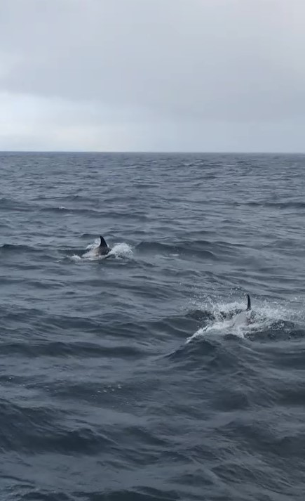 |
| Dolphins |
I have done more than my share of travelling and some of it has been by sea. I have crossed the North Sea on a blowy autumn day and the English Channel in all sorts of conditions, and never before been sea sick so I was unprepared for what happened next. Perhaps the member of the crew
who tapped me on the shoulder had a fair idea. She offered me a sympathetic
smile and a white paper bag.
I had not expected it to take over my whole body. First there was a tingling in my hands and feet which grew to take over my arms and
legs. After a while my skin began to crawl, my skull felt like it was shrinking and the little
hairs on my back and neck bristled. Then I deployed the white bag, not that I
needed it, I had gone without lunch. Sounding like a particularly demented hellfire
preacher speaking in tongues, I heard myself shouting very loudly and
totally incoherently into a paper bag. I had largely lost control of my body and totally
lost control of my vocal cords.
Then it stopped and I felt a little better. The look-out became very excited when the whale breached. Everybody else sounded thrilled, I
felt a flicker of interest, then realised the tingling was returning.
I went round that block a couple of times, eventually surrendering my coffee and fermented shark (too much information?) and then settled into
grim endurance. I began to wonder how quickly I would recover once back on dry land;
would it be like shellfish poisoning (some symptoms in common!) which lasted
days, or would there be instant relief like altitude sickness.
 |
| For those feeling well, the sea here is beautiful with or without whales |
We were out for three hours, the first 20 minutes I quite enjoyed, the last 2½ hours were dire. Many
people had spoken to me about whale watching, some with enthusiasm, others with
awe, I must be a disappointment to them. I dislike hyperbole, so I will merely say,
with total confidence, that they were the worst 2½ hours I have ever spent in Iceland.
Lynne enjoyed it, though.
Recovery, Return and Dinner
Despite my earlier doubts, I felt much better once I had planted my feet on the solidly immobile dockside and soon I felt well enough
to start the 90-minute drive back to Borganes. I did stop on the way for a
brief rest, heaving tires you out, but we arrived safely and having had no
lunch I was ready for dinner.
We had eschewed the hotel restaurant yesterday, it was an elderly, dowdy building and we feared the restaurant might be the same, but although Borganes
offers much fast food there are few proper restaurants, so we risked it.
We soon found we had seriously underestimated the hotel restaurant. I had the catch of the day which was the fattest, freshest plaice I it has ever been
my pleasure to encounter.
 |
| Plaice, Borganes Hotel |
Lynne found her Icelandic lamb very acceptable, too.
 |
| Icelandic lamb, Borganes Hotel |
I retired to bed with the strange feeling that I was one of the few people to have set out to eat fermented shark and watch whales, and enjoyed the shark more than the whale.
*Our most southerly point is Malacca in Malaysia at 2° 12´N - we have yet to visited the southern Hemisphere.
The blog's most westerly point is the Crooked River High Bridge in Oregon, USA at 121° 12´W, though unblogged we have been to La Push, Washington, USA at 124° 38´W
Our most easterly point is Kaesong, North Korea at 126° 33´E.
Part 1 Introduction to Reykjavik
Part 2 West from Reykjavik along Route 1
Part 3 A Calving Glacier, a Basalt Pavement and an Otherworldly Canyon
Part 4 Vik, Skógafoss and Skógar
Part 5 The Golden Circle, Gullfoss, Geysir and Þingvellir
Part 6 The Snæfellsnes Peninsula: Whale Watching and Fermented Shark
Part 7: Covid Testing, Grindavik and the Blue Lagoon
Part 8: A Day in Reykjavik
No comments:
Post a Comment