Monday 23 June 2014

Dublin (1) First Impressions

O'Connell Street, The Liffey and Irish Pubs

Dublin: Making a Start


Ireland
Dublin
We have done more than our fair share of travelling over the last forty odd years, first driving round Europe with a tent in the back of the car, then venturing further afield - North Africa and North America - and more recently we have become fascinated by India and the Far East. In all this wandering we had never taken the short trip to Ireland. Now we have put that right and Ryanair took less than an hour to fly us from Manchester to Dublin for a three day mini-break. 'There are better places to visit in Ireland than Dublin,' the girl sitting next to us on the plane said. She was a Dubliner, and maybe that coloured her judgement, or maybe she was right, but you have to start somewhere and for us Ireland started with a ride into town on the airport bus.

The quality of the light, the short green grass and the wheeling seagulls made it clear that we had landed by the coast. Beyond the airport, and after a short ride on Ireland’s M1, the bus dived into a lengthy tunnel and emerged into the city. The route passed the docks before turning to follow the Liffey into the heart of Dublin and then zig-zagging through streets, some broad and some that appeared far too narrow for a double decker bus. We hopped off near our hotel at the top of O'Connell Street.

A Short Walk from the Parnell Memorial to The Dublin Spire via Moore Street Market then Down to the Liffey

Charles Parnell

After checking in, we strolled past the Parnell monument. Charles Parnell (1846-1891) was an unusual Irish nationalist in that he was a member of the Anglo-Irish elite, and a land owner and landlord who fought for land reform. A man of great charisma he was politically damaged by a scandalous divorce and died of a heart attack aged only 45. It has been speculated that had he survived, the birth of an independent Ireland might have been a lot less bloody.

The Parnell Monument, Dublin

The rotunda behind the monument dates from 1757 and was the world's first purpose built maternity hospital.

Moore Street Market

From Parnell Square we turned into Moore Street where the legendary Molly Malone plied her trade. Maybe we were too late in the day but it seemed a rather half-hearted market. We were amazed by how few Irish voices we heard. There were plenty of tourists, and we were adding our non-Irish tones to that, but there were also many non-Irish non-tourists. There were brown and black faces in abundance, the hotel reception staff were south Europeans, Vietnamese and Koreans ran the restaurants round the corner, the Moore Street stall holders seemed to be mostly Chinese, while the street also has a Polish café and supermarket.

Moore Street Market, Dublin

Henry Street, Admiral Nelson, The Floozie in the Jacuzzi and the Spire of Dublin

At the end of Moore Street we turned west along Henry Street, a long pedestrian shopping street; much of it looking a little sad and down at heel.

Turning back towards O'Connell Street we found ourselves heading straight for the Spire of Dublin. Had we been here in the early 60s we would have been walking towards Nelson’s Pillar. There had been much rejoicing when the news of Nelson’s victory at Trafalgar reached Dublin. The city fathers were quick off the mark and perched the admiral atop a 40m high pillar over 30 years before London erected his column. Although a third of Nelson’s sailors at Trafalgar had been Irish, the pillar was the brainchild of the Anglo-Irish protestant elite and after independence there was much discussion about whether it was an appropriate monument for the capital of an independent nation. Discussions came to an end in March 1966 when the IRA, with their usual preference for bombs over democratic process, blew Nelson up.

In the late 1980s the site was occupied by Anna Livia, a sculpture by Éamonn O'Doherty, better known as 'The Floozy in the Jacuzzi.' Many Dubliners grew to like her, but the authorities wanted something more 'appropriate' and she was removed in 2001. After ten years in a crate she was repositioned in Croppies Memorial Park, appropriately beside the River Liffey - Anna Livia Plurabelle was James Joyce's embodiment of the river in Finnegan's Wake.

Henry Street pointing straight at the Spire of Dublin

As part of the 1999 redevelopment of O'Connell Street a competition was held to find a suitable replacement, and The Spire was the winning entry. If this was the winner I dread to think what the losers looked like. The architects describe it as having an ‘elegant and dynamic simplicity bridging art and technology.’ It has won several international prizes, but to me it looks like the wrong monument in the wrong place - though the ‘right place’ for a 120m steel knitting needle eludes me.

Down to the Liffey past the Post Office

We continued towards the Liffey, passing the Post Office which played such an important part in the 1916 Easter Rising. The poorly organised rebellion was launched, with German help, while 200,000 Irishmen were voluntarily fighting in British uniforms against Germany. The rising failed to generate momentum and was quickly put down. As if determined to snatch defeat from the jaws of victory, the British authorities put the leaders in front of firing squads and turned them into heroes.

At the end of the street, we crossed the road to the O’Connell Bridge and had a stare at the Liffey. A line of beggars sat on the bridge, crouched on the pavement below the parapet at 10m intervals, each silently holding up a plastic cup. Business seemed poor. Their light brown skin and the women's long dresses suggested they were not Irish, perhaps they were eastern European Roma, but as they are the default whipping boys for all sorts of social ills, I will refrain from jumping to conclusions [and we came across beggars in the next two days who were genuinely local].

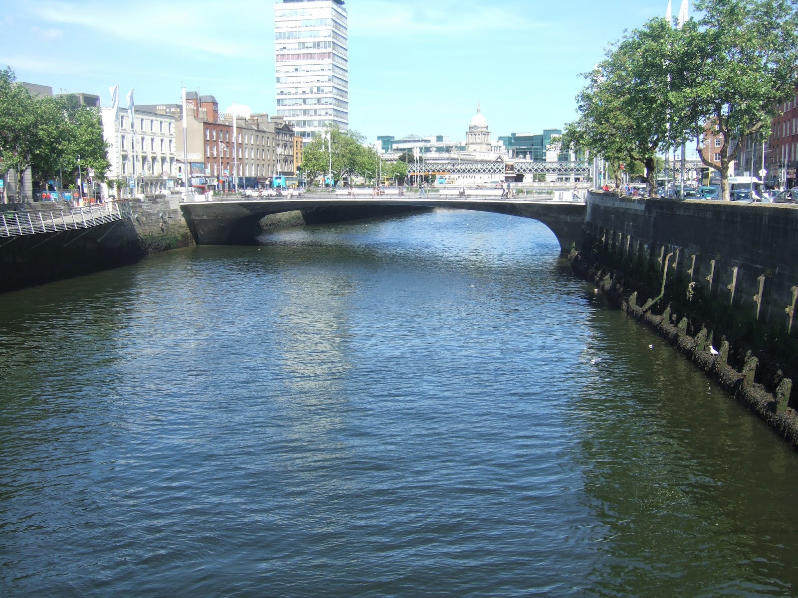
The River Liffey, looking downstream from O'Connell Bridge

Daniel O'Connell

We turned to face the O’Connell monument. Daniel O’Connell (1775-1847) trained as a lawyer and became a politician. He fought tirelessly for Catholic emancipation and was an important part of the successful campaign to permit Catholics to sit in the Westminster parliament. His battle against the 1801 Act of Union that merged Great Britain and Ireland was less successful, but he was a man of great principle (he never advocated violence) and charm and he was widely admired on both sides of the Irish Sea.

On the whole I am not keen on nationalists, people who would kill or die for what Kurt Vonegut called a granfalloon - a collection of people with a label who believe that gives them something in common, but O’Connell was, by all accounts, an admirable man. It was a shame, then, that a pigeon was semi-permanently stationed on his head, but perhaps he would have seen the funny side.

Daniel O'Connell and his resident pigeon

Back up O'Connell Street

O'Connell Street is wide, reputedly the widest street in Europe, and has plenty of room for a line of statues, from O’Connell at the bottom to Parnell at the top. Some are of worthy citizens, like the 1879 statue of Sir John Gray who greatly improved Dublin’s water supply, while others, predictably, are of nationalists William Smith O'Brien and Jim Larkin.

William Smith O'Brien (front), Sir John Gray (behind - and that wretched spire

There was also Father Matthew, the apostle of temperance. A well-meaning man, no doubt, but fighting an uphill struggle, we thought as we turned into a side street and headed for Branigan's Beer Emporium.

Father Matthew, the apostle of temperance, O'Connell Street

Irish Pubs

The world is full of ‘Irish pubs’ and I carefully avoid such folksy fakes whether in Portugal, Laos or anywhere between. The sole exception was PJ Murphy’s in Hong Kong where we were dragged by our daughter with a cry of 'Melted cheese!' Living in mainland China, where cheese is unavailable, she had come to Hong Kong as much for a toasted cheese sandwich as to meet her parents.

Branigan's Beer Emporium

Branigan's really was like an ‘Irish pub’, folksy, but for once totally genuine. In the late afternoon it was hardly busy, but the barman greeted us like friends and eventually brought us some Guinness - it does not pay to be in a hurry, Guinness needs time to settle.

I have often been told that Guinness is better in Ireland. I was sceptical, but it did not take me long to agree that it is certainly different. The strongly burnt/bitter flavour of highly roasted barley is absent and it is a softer, creamier more approachable brew. And does that make it better? I tend to believe that anything that is easier to eat or drink, anything that panders to the common denominator is dumbed down and hence inferior, but I am not totally consistent - I do not lunch on dung sandwiches, and I prefer honey to beeswax like everybody else. My conclusion? Irish Guinness is rich and creamy and in every way lovely, while Guinness in England in harsher and more bitter, and if that is the general view I will happily go along with it.

Madigan's Drinking Emporium, O'Connell Street

Madigan's Dinking Emporium

In the evening we walked down O'Connell Street to Madigan's a self-described drinking emporium - Dublin is full of emporia. It was another typical Irish pub with dark panelling, fancy woodwork and many alcoves. Again the welcome was warm and the Guinness good, but unlike Branigan's, the clientele was cosmopolitan. Our alcove contained three Irishwomen, a Dutch couple and two Germans as well as us. A party of Dutchman sat by the bar in orange football shirts, talking to some English lads and pretending to be sympathetic about their team’s very different fortunes in Brazil.

Madigan's Drinking Emporium, O'Connell Street

The food was not art. My Irish cottage pie differed from its English counterpart by having 'strips of slow cooked Hereford beef’ as well as mince. It was saved from being unpleasantly dry by the pot of gravy served with it. Lynne’s stuffed Gaelic chicken breast gained little from the promised whiskey in the sauce but benefitted greatly from being stuffed with well-flavoured wild mushrooms. It was all comfort food, but none the worse for that and reasonably priced.

And what have we learned from our first venture into Dublin?

1) We have always thought of the Irish as being a people who emigrate, and indeed they have made major contributions to the populations of English speaking nations around the world – even the Prime Minister of Papua New Guinea is one, Peter O’Neill. But equally Ireland, or at least Dublin, is home to many immigrants.
2) Guinness in Ireland really is different – indeed it really is better.
3) Irish pubs are extraordinarily welcoming, and the bar staff exude an effortless charm that has to be felt to be believed.
4) I am not going to escape from Irish nationalism for the next three days. No resentment is aimed at me personally, so I’ll just have to suck it up.

Monday 5 May 2014

Into the Quantocks: Day 21 of the South West Odyssey (English Branch)

The South West Odyssey was a long distance walk.
Five like-minded people started in 2008 from the Cardingmill Valley in Shropshire and by walking three days a year finished at Start Bay on the South Devon Coast in May 2019.
  
 [With updated text and photographs 21/09/14]

It is always pleasing when the B and B is the finish of a day’s walk and you start the next day by simply walking out the door. So it was today – but not for me.

Leaving home on Thursday I picked up my boots and felt a hard piece of the casing protruding inwards. An attempted repair was, at best, ineffective, at worst counter-productive and by mid morning on the first day a blister had already formed and burst.

Blister pads kept me going, but once the damage is done they can only slow the deterioration. By the end of the second day the inside of my right heel was an angry mass of raw, red meat. Despite medication (Ibuprofen, red wine & Famous Grouse) the pain woke me around four o’clock and I made my decision: I could not possibly manage another day.

I was unhappy watching the others set off without me, but there was nothing I could do. [In September I returned in the company of Francis and did the day's walk. We could not have picked a better day; bright sunshine, warm but not too hot for walking] Also galling was that after seven years of the Odyssey, this was the first day I could not blog from first-hand experience. However, others rallied round, and with their assistance Day 21 is not going unrecorded.


Leaving me behind at West Monkton
 Francis wrote. ‘Today we actually started from the B and B, Springfield House, something I always like, and walked up the lane towards Walford House stopping to admire its well-used dovecote.


Dove Cote, Walford House (Pic: Francis)
The lane took us round a U-curve and into West Monkton village…past the main door and through the garden of the pub where we had dined the night before….

[Francis and I dined there again and this time I ate the zebra. Before ordering I asked another diner about his  zebra experience and he said 'Well it's just a big slab of horse, really.' I disagree, Zebra has its own distinctive flavour and it was also gamey in taste and texture - I suspect it requires long hanging to make it tender enough to eat (unless you are a lion). Having walked to the pub on Saturday evening, we felt justified in starting from there on Sunday. When paying for our meal we had asked the landlord if we could borrow a space in his car park for the day. He agreed immediately and thanked us for having the courtesy to ask. Apparently a lot of people don't. They should.]

Francis strides past The Monkton
Shortly we met two alpacas in a field. The owners of the West Monkton Inn clearly must be unaware of their existence or else they would have them on the menu! (on the specials board with the zebra, ostrich and crocodile.) [The alpaca had gone, whether it had starred on the menu or just moved off we do not know]


Not our first  example of the rare Somerset Alpaca
(Pic: Francis)
Along with the alpacas, Alison noted a glamping site with 4 yurts, and Francis photographed a fine horse chestnut which looks more at home in this environment.


Horse Chestnut, West Monkton (Pic: Francis)
The route followed the West Deane Way (we had encountered the East Deane Way yesterday) to Hestercombe House. Alison noted …A few ploughed fields, but the soil was much more friable than the clay of the Somerset levels, and it was only muddy in parts, with ways round possible. There are over a quarter of a million words in this blog, but this is the first time ‘friable’ has made an appearance. I am delighted to welcome it. I had to look the word up, and for those as ignorant as I am, it means ‘apt to crumble.’


A field full of remarkably friable soil (Pic: Alison)
Hestercombe House is a sixteenth century country house with a chequered history including being the headquarters of the Devon and Somerset Fire and Rescue Service until 2012. The Gertrude Jekyll designed gardens are open to the public.

Francis writes enthusiastically We climbed through fields and bluebell woods enjoying our return to more hilly country after two days on the Levels, Alison is a little more laconic A noticeably hillier day than the previous days.


The Vale of Taunton from Hestercombe (Pic: Alison)

After descending into and out of Gadd’s Bottom.....
 
Down into Gadd's Bottom (pic. Alison)

Francis admitted they arrived a little late in Kingston St. Mary for a coffee break. We found a bench in the churchyard which served our purpose only to discover, after leaving, a nicer one in a better, more sheltered location in the village.
Coffee break, Kingston St Mary (Pic: Alison)
 [The descent to Kingston St Mary's involves glimpses of the village through trees and gaps in hedges. It is a delightful place and I could not help comparing the soft lushness of southern England with the desolate moors and windswept hills we had crossed on our approach to Hadrian's Wall ten years ago. If humankind could not organise a comfortable and prosperous life for itself here then it had no hope anywhere. And this area did grow rich, mainly on the wool trade which is why a small village could afford such a fine church.


St Mary's, Kingston St Mary
Mostly 13th century, though the tower is 16th century
Benefitting from experience we went on to the second bench in the village. The oak tree was planted to celebrate Queen Victoria's Diamond Jubilee in 1896, the bench was added to commemorate the Millennium. We drank our coffee leaning back on wrought-ironwork depicting the village past, present and future.


Millennium Seat, Kingston St Mary

And then the route…took us up through the extensive grounds of Tetton House from where Alison observed we could see the main climb of the day, Cothelstone Hill, ahead. [I looked at Cothelstone Hill and said 'that's not much.' 'Wait til you get to Ball Lane,' Francis said ominously]


Cothelstone Hill looking less than imposing from Tetton House
Tetton House was built in 1790 but largely remodelled between 1924 and 1926 by H S Goodhart-Rendel, architect, writer, musician and all round clever clogs – though I am sorry to say I had never heard of him before.

Leaving the grounds over a stream, way finding, in the words of Francis, became a little confused.. but it was Alison who saved the day with some clever map deduction and good observation skills spotting a gate with a sign on a high fence that we had all missed. Or as Alison put it I brought us back to the route from which we had strayed. I feel pleased at my improved map reading since leaving Stafford, due to a combination of varifocal glasses, having a map, and practising. Well, having a map does help. Mike saw the incident as Alison frantically pointing out the path across the stream and the gate into the wood which was easy to see by all except Francis who was determined in the direction he was taking (60 degrees to the east of it) and that we were to follow! He goes on, with commendable honesty to admit, I was no use … as I had left day 3 map in my 'van!


The site of the navigation difficulties.
That does look the obvious place to cross the stream and the stile into the woods that only Alison
could see is on the left hand edge of the picture two thirds of the way up.
Francis and Brian had strayed into a field over to the right
Once on the right route it did not take long to reach Ball Lane and to start slogging up its 1.5km ….
[Francis warned me, and he was right. Ball Lane is always just steep enough to feel like hard work, but never quite steep enough to get the climb over and done with swiftly. It is a slog, more precisely, a long slog.]


Ball Lane


Resting after the climb up Ball Lane (Pic: Francis)
…and then a bit more to reach Cothelstone Hill, a dizzying height of 332m, part of the Quantock Hills. Cothelstone maybe considerably lower than Dunkery Beacon, assuming we reach Exmoor next year [we did], but it is the highest point on the walk since the Herefordshire Beacon (338m) on the Malvern Ridge.
 
View west from Cothelstone Hill (Pic: Francis)

Having reached the top, Francis continued we didn’t hang around up there long as the wind was strong and quite cold and we were running late. He did pause on the way down to photograph the bluebells in Twenty Acre Plantation. I am delighted to say they appear to be the native British bluebell - and looking as good as they get. [It was warm and sunny on top of the hill this time. The view west was the same but the weather conditions gave us an even better view north. Ignoring the nuclear power station at Hinkley Point, we could see the whole sweep of the Somerset coast to Weston Super Mare and beyond, and across the Bristol Channel to Barry and Penarth. What we had no chance of seeing in September were the bluebells in Twenty Acre Plantation.]

Bluebells, Twenty Acre Plantation (Pic: Francis)
Alison observed that we were beginning to realise that it would be another long morning.There was even another climb up from the bottom of Cothelstone hill before descending to the pub at West Bagborough along the road, as a last minute short cut.

[I understand the need for a shortcut on the third day of three, but we were only there for the day so we carried on, taking a fine path that does not quite cross the summit of Lydeard Hill, though at 350m the path set a new high point for the day. They are proud of their colony of Dartford Warblers here, but Francis did not see one. I might have done, but I have no idea what a Dartford Warbler looks like]


Francis looks for Dartford Warblers on Lydeard Hill
We descended to West Blagborough on a path that was rougher and steeper than Ball Lane. It was redeemed by a) being downhill and b) being shorter.
The descent to West Bagborough
This was intended to be a short day’s walk before the long drive home. The previous evening we had chopped the finishing point from the hamlet of Triscombe to West Bagborough, and now a short-cut was necessary to make West Bagborough in a reasonable time. This year’s instalment of the South West Odyssey (English Branch) ended in the Rising Sun at West Bagborough. Well done! to those who made it. I am sorry I was not there.

[Well I got there, - four months late. We had a very welcome (and, I think, deserved) pint of shandy sitting in the sun outside the Rising Sun]


Wild ponies, Cothelstone Hill (Pic: Francis)
Perhaps we are walking a little slower than we used to, it does not feel like it, but we were all in our forties for 'Go West', we are in our sixties, now. I think these walks were slightly longer than the last couple of years, but then Cothelstone Hill apart it was as flat a three day walk as can be arranged without going round and round a running track. Something to think about before next year perhaps – but there will be a next year, and I will find time, hopefully during this summer, to get down to Somerset and fill in my missing section. Thanks to those who offered to accompany me. I hope to take at least one of you up on it. [Big thanks to Francis who was willing and available on the date I picked]


Thanks to Francis, Alison and Mike for the contributions and to Brian for doing two shuttle runs in the afternoon so that I could go home in the morning.


The South West Odyssey (English Branch)

Sunday 4 May 2014

Along the Parrett and over the Tone: Day 20 of the South West Odyssey (English Branch)

The South West Odyssey was a long distance walk.
Five like-minded people started in 2008 from the Cardingmill Valley in Shropshire and by walking three days a year finished at Start Bay on the South Devon Coast in May 2019.

Mike and Alison T spent the night in their motorhome, the rest of us stayed at the Unicorn Inn, Somerton. Re-gathering at our chosen parking place at the eastern extremity of Langport, Mike looked sprightly but Brian, Francis, Alison C and I were weighed down by an enormous full-English - hopefully we would feel the benefit later.
 
Ready to leave Langport

Our first task was to find the route from the High Street to the bank of the River Parrett. After a false start walking down a dead end, our second attempt was more successful and we soon passed under the railway line on the path beside the wide but scarcely moving river (the Parrett drops 20cm/km between Langport and Bridgwater). We would follow the dry and well-made path along the levee for four kilometres or more. As the Parrett wandered to our left, the smaller River Sowy charted a much straighter course to our right. Beyond, Aller Moor stretched away to the low ridge where the village of Aller stood.


Beside the River Parrett
The River Sowy and the moor were much lower than the Parrett which lay between two metre high levees. Several times we crossed areas of hard-standing; presumably for the pumping equipment used during the floods to heave the water from low-lying moor over the levee and into the Parrett. Cattle grazed on Aller Moor, the grassland looking to have recovered remarkably well from the winter's inundation.


Looking across Aller Moor to the village of Aller

We passed the interestingly named Oath Farm on the far side of the river, swiftly followed by Oath Lock, below which the Parrett is tidal.

Opposite a house in the village of Stathe with a fine stand of willows and a magnificent cedar, we rested on a bench donated in memory of Stan and Doris Gadsby. I have no idea who they were, but I am grateful to them.
Stathe and a magnificent cedar
Crossing the river we followed the East Dene Way along the southern side of a ridge with West Sedge Moor to our left.

Re-crossing the railway line we took Railtrack’s wise advice to ‘Stop, look and listen.’ I appreciate the occasional statement of the bleeding obvious.


Mike crosses the main London to Penzance railway line

Mostly the going was fairly easy, though ploughed fields are hard on the legs. We also encountered a local speciality, v-shaped stiles with some of the vees rather narrow for bulky people to squeeze through.

Although we were on a recognised long distance pathway (the East Dene Way is a 70km circular walk through the levels starting and finishing in Taunton) there was one small section, perhaps no more than 30m long, that had obviously not been walked this year. Waist high nettles posed a considerable threat to those in shorts, which was everyone except Alison. Fortunately Alison was carrying a walking pole – not much use for its normal purpose in this flat land, but handy for slashing down nettles.
V-shaped stiles leading into the nettle patch

While crossing a grassy field a strange honking sound made us all look skywards to see five large, ungainly birds with stubby rectangular wings, long almost dangling legs and gawky necks. Swiftly and confidently identified by Brian and Francis as common cranes, they circled above us for some time. A rare site in this country, though a breeding group is well established in Norfolk, they caused immoderate excitement among the birders, but if I am going to look at birds I would rather observe something with a touch more elegance.

The village of Woodhill retains a functioning pub. We were briefly tempted, but there was far to go and it was early yet, so we nobly carried on.


Through Woodhill
After rounding Stoke St Gregory we were making our way to the highest part of the ridge when we encountered another (or maybe the same) mystery crop, this batch harvested and set on palates to dry. The sticks were surprisingly sturdy, maybe these were hazel for making hurdles. In the absence of anybody to ask we could only speculate.

Hazel? Maybe, maybe not
We followed the ridge towards Moredon.....

The ridge to Moredon with Curry Moor on the right
...where a farm breeds pheasants by the thousand. Most were the Common Pheasant, which I can see at home any day, but several enclosures contained species I had not seen before and have been unable to securely identify.


White Eared Pheasants from China? A bit of a guess.

From Moredon we descended the end of the ridge into North Curry.....


Descending to North Curry

...a smart and prosperous looking village with a church that boasts an octagonal tower with a peal of eight bells. The Bird in Hand was open, offered free roast potatoes on the bar and Otter Bitter in the pumps. We still had a long way to go so we limited ourselves to a single pint.


The Church of St Peter and St Paul, North Curry
Despite our moderate drinking we all set off in the wrong direction, but sanity reasserted itself and we located the correct road to Knapp. We had not thought we were walking particularly slowly, but we were behind schedule so we took the direct minor road rather than the more circuitous field paths. If we had not walked the extra three kilometres yesterday, we would have missed our lunchtime drink and still been a long way from the finish.


Brian leaves the Bird in Hand, North Curry
Roads are hard on the feet, but you get from A to B with reasonable speed and sometimes see things you would not see on field paths. In our youths the horse and cart was a sign of poverty, but over the years they have turned into rich mens' toys.


Horse and trap on the road to Knapp
From Knapp we made our way to Bird's farm from where the line of descent to the River Tone was obvious and at the bottom we turned right along the minor road to the village of Ham and a footbridge over the river. I was convinced we should turn left, but found myself in a minority of one. After a slow and careful explanation I was finally convinced that everybody else was right, but my sense of direction, which is normally fairly reliable, continued to demand a left turn.


The descent to the River Tone
The Tone rises in the Brendon Hills and flows away from the coast through Taunton (Tone town) and eastwards across Curry Moor. It then reaches the Parrett and discovers that, like me, its sense of direction was sending it the wrong way


The bridge over the River Tone at Ham
(Picture credit Francis)
After the Tone, field paths took us to the railway line which we crossed for the third time that day and the second time by walking directly across the rails. Then we crossed the Bridgewater and Taunton canal, though we used a bridge as not even Francis can walk on water.
 
Over the Bridgwater & Taunton Canal
A gently rising path took us up to Creechwood Terrace, at the north end of Creech St Michael, through another mystery crop. We were able to get a close look at this one and found it soft-stemmed with bamboo-like rings. Although superficially like yesterday’s osiers this was on well drained land and I suspect it was elephant grass destined for a bio-mass power station but, like the osiers, it might be something else.


Mike and Alison approach Creechwood Terrace through what might be elephant grass
A minor road took us across the M5 which we had crossed in the opposite direction in 2010 (Upton-on-Severn to Andoversford) on Day 7. The footpath after the motorway was labelled ' cul-de-sac', which gave us a moment’s pause. Technically the sign was right, the path angled back towards the motorway and came to a full stop at the fence, but on the way it crossed a minor road through the hamlet of Langaller. We were able to pick up that road, and find our way to a field path which would take us the last kilometre to our B & B in West Monkton.
 
Over the M5, again

That should have provided a simple finish to the day but half way up we were distracted by a commotion in the hedge. A magpie was hanging upside down, one claw ensnared in bailer twine tangled round a strand of barbed wire. Every so often it would flap frantically in an effort to break away, then dangle for a while as it built up the energy for another futile bid for freedom.


You never know what sort of dangling bird is going to be just round the corner.
Taking a clasp knife from his pack, Mike leaned into the hedge and grabbed the struggling bird. To me it looked like an excellent way to get pecked, but once he had a firm grip it went still. He picked patiently away at the bailer twine and eventually managed to free it from the wire. It had lost some blood, but appeared largely undamaged by the ordeal. Mike held the bird with two hands while Brian took the knife and removed the bailer twine wrapped round its claw.

That done Mike threw the magpie into the air. Momentarily it seemed confused by its sudden freedom, then flapped up into a tree and, just to prove its feet were undamaged, hopped from branch to branch.

'Last time I used that knife I was cutting a peach,' Mike remarked. Alison suggested it would probably be wise to sterilize it before his next peach.

That was almost the end of the day's excitement, but the path finished at the dual carriageway A38. We had to cross it, which was life-threatening, and then walk along it, though fortunately only for 50m before turning up a side track to our B & B and the end of a long day's walk - which would have been over-long if we had not done the first three kilometres yesterday.

We dined a short drive away at the Monkton Inn where the South African landlord had a menu which included zebra, ostrich and crocodile. Mike had pork, I had a duck breast and everyone else had fish and chips. Ah well, maybe next time.


The South West Odyssey (English Branch)