Thursday 26 July 2012

Bolton Priory and The Strid

A Medieval Priory and a Country Estate Beside the Rive Wharfe

Thursday the 26th of July was our 37th wedding anniversary. 37 is a big, scary number and neither of us can quite understand where all that time went.

37 Years after the event

Bolton Priory, Yorkshire Dales National Park


North Yorkshire
In celebration we set off northwards. After 60 miles up a busy, but moving, M6 we turned onto the M65. I often confuse this road with the River Congo, not because it teems with crocodile and hippo – they are manifestly rare in central Lancashire – but because it leads straight into the Heart of Darkness. Why I (and several others) have a massive downer on the worn-out and drab former mill town of Colne is a story for another time – but have you ever spent a night there? Beyond the horror (and, indeed, the horror) the countryside reasserts itself and half an hour later we entered the Yorkshire Dales National Park and arrived at Bolton Abbey/Priory.

Abbey or Priory?

Bolton Priory - the former monastery and its now part-ruined church - is often erroneously referred to as Bolton Abbey, a confusion that goes back far enough for the adjacent village to actually be called Bolton Abbey. The difference between an Abbey and a Priory is so slender it is sometimes invisible, so who cares anyway?

A sheltered plot beside the River Wharfe was given to the Augustinian order in 1159 by Lady Alice Romille of Skipton. The Priory was erected soon after.

Photo:
A sheltered spot by the River Wharfe

Despite Scottish raiders causing a temporary abandonment of the site in the 13th century, the priory largely prospered until Henry VIII decided otherwise.

At dissolution in 1539 the valuable lead was stripped from the roof to enrich Henry and ensure the priory’s ruination, the main church alone was spared as it was also the parish church of Bolton Abbey village.

We had not expected such a venerable ruin to have changed since our previous visit in 1975 (on our honeymoon) but we were wrong: the west tower – left uncompleted at the dissolution now sports a neat wooden roof and a small bell turret. As it forms the entrance to the still functioning parish church, these were worthwhile additions – and it only took 450 years to get round to them.

Under the West Tower, Bolton Priory

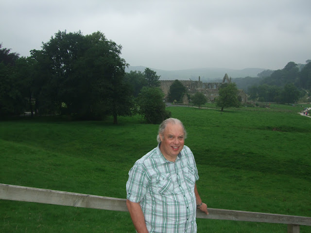
Inside the church is a huge Pugin stained glass window. 37 years ago I probably gave it no more than a glance, but I did not know then that I would spend 20 years teaching in a Pugin designed building. The Gothic Revival often involved locating the top and then going over it, but the windows are more restrained and very effective in their setting.

The rest of the Priory is an elegant ruin. Not a phrase that meant anything to me in 1975, but as I progress through my 7th decade, it seems something to aspire to.

The abbey and me - a pair of elegant ruins

Stepping Stones, Bolton Abbey

Within the Priory grounds, the River Wharfe is crossed by stepping stones which present an irresistible challenge to children – and indeed many old enough to know better.

The two girls in the centre of this picture were struggling, so one of them decided to slip into the water and wade, holding her friend’s hand to steady her. The plan might have had some merit had the girl wearing the shorts decided to wade, but it was the girl in the jeans who entered the water.

The Stepping Stones, Bolton Priory

Further on there is a missing stone and they both decided to wade the gap. A little later some children reached this point and the girl in the jeans waded out to piggy-back them across. At the deepest point the water reached mid-thigh level; I do not know how much she enjoyed the rest of her day walking round in soaking jeans, but it would not have been my choice of attire.

For those actually needing to cross the river there is a perfectly serviceable footbridge just out of the picture to the right.

The Strid

A mile or so north, though still on the Bolton Abbey estate, is the Strid Wood car park. A fifteen minute walk through the woodland, mainly native oak and silver birch with a pungent carpet of wild garlic, brought us down to the Strid itself.

On the way we paused at the point where, in 1815, William Turner (not to be confused with his better known contemporary JMW Turner) stood to paint ‘The River Wharfe with a Distant View of Bardon Tower’ – he specialised in 'does what it says on the tin' titles.

The River Wharfe with a Distant View of Bardon Tower, 1815

Lynne’s photograph shows some changes, most notable that Bardon Tower – built in the 16th century as a hunting lodge - is now a ruin. Turner has taken liberties with parts of the scene, but we could only photograph what was there, he could paint what he wanted us to see.

The River Wharfe with a Distant View of Bardon Tower, 2012

The Strid is a gorge in miniature, the water flowing through the confining rocks at the southern end was deep, dark and deceptively calm. The Strid is hardly at its most turbulent in July – in a hot year the river almost dries up - but given the weather this year, I had expected more turbulence and white water.

The Strid, south end

At the north end the water was rushing through the narrowest constriction. The name ‘Strid’ is derived from Anglo-Saxon ‘strythe’ meaning turmoil or tumult, but it also suggests the river is narrow enough to be crossed in a stride. It would be a big stride, but it is remarkable that all the water flowing between the stepping stones just a short distance downstream passes through this narrow channel.

The Strid, north end

We walked back up to the car park, which gave me an opportunity to photograph Lynne walking uphill, a stance regular readers might recall from Vietnam.

Up the hill from The Strid

We moved on to Ilkley and its renowned Box Tree restaurant to complete our celebrations, and that will be the subject of the next post.

Monday 9 July 2012

Dunstable and the Olympic Torch

We Missed the Olympic Torch Relay Nearer Home, but Caught up in Dunstable

Bedfordshire

Why Dunstable?

Why Dunstable? Well, we were staying nearby, cat sitting while daughter, son-in-law and infant were on holiday. I drove them to the airport yesterday (you can drive to Luton airport without ever encountering Luton, which is a blessing).

This morning they were in Rome, Lynne and I were in Dunstable. Where would I rather be? Which would I rather be writing about? But Rome has been extensively chronicled by great writers, inconsequential bloggers and everybody in between, so what is there to add? And today Dunstable has something else, something Rome has not seen for over fifty years. Today Dunstable has the Olympic Torch.

Having missed the torch twice when it was much closer to home, we made an effort this time and were in Dunstable High Street by 6.15. The torch was not due for an hour and a half, but we wanted a good spot, and we wanted to be in the front.

The Varying Architectural Styles of Dunstable

The charms of Rome are well known and obvious, those of Dunstable more hidden - if they exist at all. We first drove through the town five years ago and immediately it felt wrong. I have been there many times since and still struggle to find anything to like about it. It is not the people, by and large they seem as decent as anywhere else, nor is the town especially poor or down at heel; indeed some regard it as the posh end of Luton (though that may say more about Luton than it does about Dunstable). It is not even that the buildings are especially ugly, well not all of them. It is the ensemble that is wrong, the way they are put together.

The charms of Dunstable

Dunstable has at least one building in every architectural style from medieval to last week, and they have been plonked down side by side with no attempt at harmony, no thought as to how they may look among their neighbours. It makes Dunstable seem sad and unloved. I feel sorry for the current planners; it all went wrong so long ago there is no way back now, no non-apocalyptic exit to their blind alley. Perhaps John Betjeman’s ‘friendly bombs’ should have been aimed at Dunstable, not Slough.

Banks can go bust in unison, but they can't co-ordinate their buildings, Barclays and Lloyds TSB, Dunstable

The Crowd Gathers

To give them their due, the good people of Dunstable turned out in their thousands, lining the High Street several deep for as far as the eye could see. And they were the ‘good people’ so why such a huge police presence? They arrived by the minibus load, they arrived on motorbikes, they arrived in marked and unmarked police cars and they hovered overhead in a helicopter. There were enough of them to deal with a riot, but the worst that was ever going to happen was a little dropping of litter, and that mostly by accident rather than malice.

The crowds begin to gather, Dunstable High Street

Police and Sponsors

The staff of the local branch of Lloyds TSB were busy unrolling a banner, handing out balloons and ensuring that everybody who wanted had green and yellow ribbons to wave – by sheer co-incidence Lloyds TSB colours.

Nothing happened for quite a long time. The road was eventually closed to traffic, though the occasional police car drove by, their occupants waving to the crowd as though they were the attraction.

Then nothing happened again. At 7.40, right on time, a flurry of police motorcycles – enough outriders to bring a smile to the face of a third world dictator – heralded the advent of the sponsor’s floats. I have mentioned one of them already (because of their local effort), but I have no intention of naming the others.

Plenty of police outriders, Dunstable High Street

The Torch Arrives

Another wait, then more out-riders, and finally the torch arrived. The torch bearers are variously celebrities, athletes and people who have contributed something to the local community. The girl with the torch was not a celebrity (as far as I know – the world seems full of ‘celebrities’ I have never heard of) and did not move like an athlete, so we gave her a cheer for being a good citizen. And then she was gone and it was all over.

At last the Olympic Torch, Dunstable High Street

I was glad we went to see it, fleeting as it was, and I was looking forward to the Olympics, though I only intended watching on television. I hope it will, in the end, be about the community and the athletes, but it is well on the way to being hijacked by the sponsors and the police.[Update: I think most would agree my worries were unfounded and I now wish I had gone to one of the events - I would have liked to see Ussain Bolt, but I would have settled for an afternoon of weightlifting]

As we left Dunstable I wondered if the best use of the torch might have been to burn the place down and start again. Sadly the wettest June on record had given way to an equally damp July - it would be nigh on impossible to set fire to anything.

Saturday 9 June 2012

Old Sodbury to Swineford: Day15 of the South West Odyssey (English Branch)

The South West Odyssey was a long distance walk.
Five like-minded people started in 2008 from the Cardingmill Valley in Shropshire and by walking three days a year finished at Start Bay on the South Devon Coast in May 2019.

Saturday promised to be a much better day; the rain had gone, the wind had dropped and there was even a patch of blue in the sky.

Brian, Mike & Francis prepare to leave the Dog Inn
Old Sodbury
After another hearty breakfast and with Alison duly re-fetched from Yate station we set off southwards across the fields towards the hamlet of Coomb's End.

Nearing Coomb's End
From here we crossed the Dodington Estate with its sweeping vistas of sheep bespattered parkland dotted with clumps of trees for raising pheasants. The park was laid out by Capability Brown in 1764 when the estate was owned by the Codrington family, who made their fortune from sugar plantations in the West Indies. It is now the home – or one of the homes - of James Dyson who bought the estate in 2003 after making his fortune rather more ethically from bagless vacuum cleaners and air-blades rather than by exploiting several hundred slaves.

Dodington Park

A few deer would have made the view perfect, but we had to settle for a large metal sculpture of a stag watching us motionlessly from a distant bank.

Plenty of sheep but no deer,
Dodington Park

The park provides a painless way of slipping back onto the Cotswold scarp. At its highest point we could look back over the valley and see the pylons of the Severn Bridge in the distance.

Crossing the park took some time, crossing the A46 was quicker, much less pleasant and considerably more dangerous. Having survived that it was only a short step to the village of Tormarton where we were meeting Heather, Francis and Alison’s daughter, who last walked with us on Day 11 (Perrott’s Brook).


Tormarton

Heather walked out of Tormarton on the path she had expected us to arrive on and saw us across the fields on another path, though we did not see her. Even after this early sighting we had considerable difficulty finding each other. Several phone calls simply added to the confusion.

Tormarton is not large, so we eventually we succeeded and together left the village via the bridge over the M4.

Over the M4

On the southern side we crossed fields of barley, the first cereal crop we had seen since Bredon Hill in 2010.

A lone poppy in a field of barley

The Cotswold Way took us west along Beacon Lane and back towards the motorway. Brian was very proud of his new walking poles which he had bought for the princely sum of 100 Hong Kong dollars (£8) in Stanley Market. They had been unveiled on Thursday and bent on Friday so they no longer telescoped properly and Brian was walking with a lightning conductor sticking up above his head. It is a wonderful place, Stanley Market, sometimes you get a bargain, sometimes you get what you pay for.


Brian carries his periscope along Beacon Lane

We re-crossed the A46 and visited the adjacent picnic site for coffee. With a car park and vehicle inspection centre it is not the most scenic spot, but looks fine if you point the camera in the right direction.

A sedge of Cranes at the feeding table

The Cotswold Way runs briefly parallel to the M4 giving an interesting view of the motorway climbing the hill opposite.

An unusual view of the M4

We turned south and followed the boundary of another cereal field for the next kilometre. Yesterday’s rain had smeared the compacted soil with a slick of wet clay, making it difficult walking; at times it was a struggle to keep upright.

I was glad to reach the end of this field and we soon found ourselves traversing the edge of a small valley below the wall of Dyrham Park. The valley side was covered with strip lynchets, banks of earth built up on the downslope of the field by generations of ploughing. Lynchets usually indicate Celtic farming and although they appear regularly on maps they are not always so easy to see on the ground.

Strip lynchets on the far side of the valley

We descended to the hamlet of Dyrham, passing the western frontage of Dyrham Park, built in 1694. The eastern front, the work of a different architect, was built a few years later. The house, constructed for William Blathwayt, Secretary of War to William III, is now owned by the National Trust. It featured in the films Remains of the Day (1993) and Baz Luhrmann’s Australia (2008) as well as a 2010 episode of Doctor Who.


The western front of Dyrham Park

Beyond the village we found ourselves in the flattest land we had encountered since crossing the Severn Valley at the end of 2009 and start of 2010.


Approaching Doynton

The signed paths did not match up with those on the map so we arrived in Doynton unsure as to exactly where we were. Lynne waited patiently outside the pub while we indulged in a lengthy and misguided circumnavigation of the village before joining her. The Cross House was doing good business on a Saturday lunchtime, and the weather had improved so much that we chose to drink our lunch in the garden – though Lynne did not think it was warm enough to remove her fleece.


A glass of lunch in the garden of the Cross House
Doynton
As we left we passed a cricket match – what did we expect in an English village on a sunny Saturday afternoon? I merely took the picture and moved on, it was only later that I wondered what the fielding captain was doing. Why had he left so much space on the leg side? Why is the batsman not already shaping to work the ball that way? What is going on here?


Doynton cricket club - questionable tactics

With these questions still unasked we headed up Toghill Lane, climbing the Cotswold scarp for the seventh time in three days. Over the A420 we continued along the top of the hill to join Freezinghill Lane, a B road which was narrow and very busy. It was warmer than its name suggests, but the traffic made it an uncomfortable place to be and we were stuck with it for some 500m. We found what should have been our exit but the footpath sign had been reclaimed by the hedge and there was no way through.


The wooden footpath sign had been reclaimed by the hedge
Freezinghill Lane

We backtracked to a gateway, and improvised our own route through the long grass.......

through the long grass
.....and down Freezing Hill.

Down Freezing Hill

Once we had descended there was nothing for it but to start our eighth and final ascent. The Cotswolds may not be the largest of hills, and the scarp may be higher in some places than others, but climbing up and down it nine times in three days is hard work. Hanging Hill is a grassy slope, the path zig-zagging upwards through a herd of cows. Reaching the top, we arrived at the site of the Battle of Lansdown.

Hanging Hill, site of the Battle of Lansdown in 1643

The battle, on July the 5th 1643, was not one of the major confrontations of the Civil War, but it did involve some 10 000 men and resulted in the deaths of 300 of them, mostly Royalists. It was a Royalist victory, in that they pushed the Parliamentarian army from their hilltop stronghold, but they lost so many men they were unable to complete their strategic aim of taking Bath.

From the top we had views over the outskirts of Bristol, the rest of the city stretching away into the distance.

Bristol from the top of Hanging Hill

Tracking along the top of the hill, we failed to find the remains of the Roman villa marked on the map, but Lansdown Golf Course was easier to locate. The golf club had signed a route outside the course, but Francis was adamant that we should take the slightly shorter right-of-way round top of the scarp. This involved walking along the edge of a couple of fairways and we were fortunate that no shouts of ‘fore’ came our way.

The long descent started down the golf course access road towards the hamlet of North Stoke. Somewhere along this path we entered Somerset having taken 8 days to cross Gloucestershire (though hardly in a straight line). We finished the descent on yet another sunken lane which deposited us at a picnic site in Swineford near the banks of the ‘Bristol’ Avon, not to be confused with the ‘Warwickshire’ Avon which we crossed (in Worcestershire!) in 2010, nor any of the Avons in Hampshire, Devon or Strathspey.

Down to North Stoke

We had survived a day of rain and a day of wind and enjoyed a day of sunshine. Perhaps it will be sunshine all the way when (all being well) we meet here in 2013 for the next instalment; and perhaps it won't. All that remained was to return various people to their cars and then to drive home. For us that meant a trip from Swineford (near North Stoke) to Swynnerton (near Stoke-on-Trent) - from a place where pigs can cross a river, to a homestead where pigs are kept; a feeble effort from a region that can offer such nominal splendours as Pucklechurch, Mangotsfield and Wickwar.


The South West Odyssey (English Branch)