Showing posts with label UK-England-Somerset. Show all posts

Tuesday 12 April 2016

Entering Devon and Leaving Exmoor (in that order) : Day 25 of the South West Odyssey (English Branch)

The South West Odyssey was a long distance walk.
Five like-minded people started in 2008 from the Cardingmill Valley in Shropshire and by walking three days a year finished at Start Bay on the South Devon Coast in May 2019
.

South Across Exmoor from Withypool and on Towards Dartmoor

Return to Withypool

Somerset

This year's instalment started with a disappointment. Alison, who has been ever-present on this and previous walks that have taken us among other places, from Hadrian's Wall (see Intro) to Exmoor was missing. A domestic crisis cropped up two days before the start of the walk and she understandably felt this was not a time to be away. She was missed and I hope her absence is only temporary.

The surviving four walkers, and Lynne, who provides the essential logistical support gathered on Monday at the Royal Oak in Withypool where last year's walk finished. Proceedings kicked off with a good dinner.

Dinner in the Royal Oak, Withypool

In the morning we gathered for a photo outside the Royal Oak, standing in the middle of Withypool's main street – not as dangerous as it sounds.

Francis, Brian, Mike and Me
Outside the Royal Oak, Withypool - or is it a poster for a bad cop film

Withypool to Dane's Brook

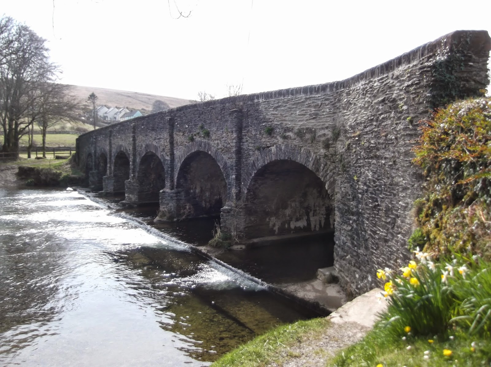
We walked through the village, down past the tea rooms whose cream tea featured at the end of last year’s walk, over the Barle Bridge and up the hill beyond.

Bridge over the River Barle, Withypool

Why Mike chose to run up this road is a mystery, but he kept a up steady pace far longer than I would have thought reasonable - or possible – even if he did flag a little before the top.

Leaving Withypool

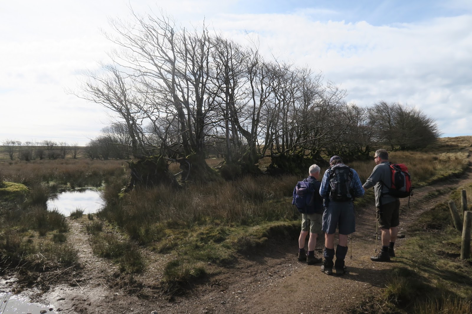
A hundred metres beyond the houses we turned onto a track across the moorland. It was a lovely surface to walk on, dry and springy after recent good weather.

Onto the open moor, Exmoor

The gradient was gentle and the path soon bought us tangentially to the ‘main’ road from Withypool where we swung away south. We swung a little early, following a narrow track, probably made by ponies (or Land Rovers), and missing the wider path hiding in the grass just a few metres away.

This might be the moment Mike spotted the wider path

We seemed to correct ourselves one by one, but we were all on the wider path by the time we reached Tudball's Splats. This splendidly named location is apparently known locally as 'Four Fields' which may be prosaic, but accurately describes the almost rectangular fields marked out on the moorland long ago. ‘Tudball’ is believed to be a Somerset mangling of ‘Theobald’, but who Theobald was nobody knows. The English Dialect Dictionary (pub. 1898-1905) defines 'Splat(t)' or 'Splot(t)' as a plot or little piece of ground. The word was recorded in Devon in 963 and according to the EDD remained in use in Cornwall, Devon and Somerset- we passed a Splatts barn in 2012 (Day 14, North Nibley to Old Sodbury) in Gloucestershire (though only 5 or 6 km outside Somerset).

Tudball's Splats behind the grown out hedge, Exmoor

Crossing the moor Francis and Brian observed and confidently identified stonechat, chiffchaff, willow warbler, meadow pipit, marsh tit and kestrel. We all spotted the first swallow of spring and the circling buzzards and heard and saw a plethora of skylarks.

Less than 10 minutes from Tudball’s Splats is the Porchester Post. As we discovered last year this part of Somerset is full of useful posts telling you exactly where you are in the middle of nowhere. Lord Porchester is the title of the Earl of Carnarvon's eldest son before he inherits the earldom and this particular post was originally erected in 1796 by the Carnarvon family of Highclere Castle (better known as Downton Abbey) to mark the boundary between Withypool and the parish of Hawkridge which they had recently acquired from the Aclands - whom we encountered last year. The piece of wood in the photo is not particularly old – the post has been replaced many times.

The Porchester Post, Exmoor

Over Dane's Brook and into Devon

Devon

A little further along, Upper Willingford Bridge over the tiny Dane's Brook is of little significance as a bridge, but it marks the point where we left Somerset, through which we have been walking since 2013, and entered Devon the fifth and last county in this walk (though the precise end point remains a matter for conjecture).

Dane's Brook flowing under the Upper Willingford Bridge, Exmoor

Encroaching farmland has left only a thin neck of moorland here but beyond the bridge it opens into the larger areas of Molland and Anstey Commons. We crossed a small corner of this moorland to White Post, which is, believe or not, a white post – and also a perfectly ordinary road sign where two minor roads reach the moor.

We paused here for coffee and to consider our next move. The route Francis had chosen while sitting in the comfort of home involved setting out across Molland Common just to the right of the high point then swinging right to find a ford back across Dane's Brook.

Coffee at White Post, Exmoor

It looked fine sitting at a desk in Stafford, but less good perched on a bench on Exmoor. Although a path theoretically existed there was no sign of it on the ground, the high point was a barely discernible bump and the map was covered with those little green tussocks that indicate marshland.

Carver Doone, the villain of Lorna Doone, drowned in a bog on Exmoor and although we would have been unlikely to suffer the same fate, crossing an area called 'Soaky Moor' seemed unappealing. We would be better off, we decided, walking a kilometre along the road following the edge of the moor and then, hopefully, locating a path leading down the edge of Triss Combe.

Down Triss Combe and off the Moor to Molland

The path along the top of the combe was easy to find, though a little churned up and muddied by the resident ponies.

The path beside Triss Combe which drops away to the left

Exmoor ponies have lived semi-feral on the moor for a very long time. The local belief that they have been pure bred since the ice age is unverified, bur fossil records dating from 50,000 years ago show that local horses have changed little. They almost became extinct after the Second World War and are still threatened with only 500 in Britain, mainly on Exmoor, and another 300 elsewhere.

Exmoor Ponies

Our descent of the combe eventually picked up a farm track at which point we crossed the southern boundary of the Exmoor National Park. Following the track, we regained the planned route just west of Smallacombe Farm. From here field paths took us down to a small, unnamed stream and up the other side.....

Down to a nameless stream nearing Molland

....from where we descended across the fields to Molland.

Over the fields to Molland

Molland and the London Inn

Molland has a population of 200, half what it was in 1900. It has a large 15th century church and, remarkably for a small and remote village, a fully functioning pub. The 16th century London Inn proved welcoming and provided us with a very decent glass or two of lunch. The morning had started cool and April sunshine takes a while to build up much warmth but as the morning had progressed outer clothing had been shed and it was now balmy enough to sit outside the pub. The sign suggested it had once been a coaching inn while the name hinted that passengers were en route for London. I am no expert in old coaching routes but I suspect any coach bound for London that found itself in Molland was seriously lost. I would, though, congratulate all those concerned with keeping the pub open when so many have closed and I hope their promised new website will give some historical information. [Update June 2022: The promised website came and went, but the pub remains open when so many have closed. For that three hearty cheers.]

Day 25 of the South West Odyssey

Molland to Knowstone

Our approach to Molland, descent to a stream followed by a sharp incline established a pattern that would become familiar over the next two days.

Down through Bond Wood

Climbing the low hill south of the village allowed us to descend steadily through Bond Wood to re-cross the nameless stream we had encountered earlier. The stiff climb up the other side eventually provided a good view back to Molland.

Looking back to Molland

Soon after, we joined a minor road, the start of some 4km of road walking broken only by a brief shortcut contouring through Middle Lee and East Lee farms. Most of this flat stretch involved walking east with the sun on our right shoulders. Roads might be hard on the feet, but the weather could not have been better.

For the final kilometre we turned south, joining the Two Moors Way, a 166km long footpath crossing Dartmoor, Exmoor and the land between. It is usually described as stretching ‘from Ivybridge in South Devon to Lynmouth on the north coast’ inferring most walkers travel south to north. We were going the other way, which several locals told us was odd, if not downright perverse – so why did we encountered so few walkers coming the other way?

Francis checks the map

We crossed the River Yeo, one of eleven rivers of that name in Devon and Somerset, and not the most important of them.

Near Yeo Mill

From the bridge we climbed gently upwards to the end of the road. The next two kilometres crossed Easter New Moor and Owlaborough Moor, which despite their names, are level(ish) farmland rather than moorland, ending with a wooded descent to the hamlet of Owlaborough.

Wooded descent into Owlaborough

I regret not having a picture of Owlaborough’s unusual small circular barn. According to a local, very possibly the owner, until a little over a hundred years ago a horse plodding round in circles in this barn providing the motive power for the threshing machine next door.

Back on a minor road we descended to a bridge over a stream called The Crooked Oak, then climbed up to the village of Knowstone, the nearest settlement to West Bowden Farm, our B &B for the night. We had been advised that if we wanted to eat in the Mason's Arms we would need to book, which Francis had duly done. This morning the landlord of the Royal Oak in Withypool had casual mentioned that the Mason’s Arms was a Michelin starred restaurant.

The Mason's Arms (thatched building set back from the road), Knowstone

We paused to read the menu, which read very nicely as you would expect. It also involved big numbers. I am not averse to a little fine dining - Lynne and I enjoy an annual wedding anniversary excursion into that world, as this blog will witness (click on the Fine Dining label on the right). This, though, was a walk, and walks demand simple, hearty fare at simple, hearty prices.

To West Bowden Farm and Dinner at The Stag in Rackenford

We followed the Two Moors Way through Knowstone and down the minor road towards the A361, turning off after a kilometre onto the farm track leading to West Bowden. We crossed a field of spring lambs...

Spring lambs, West Bowden Farm

...then after 200m the path dropped sharply to the farmhouse.

Down to the farmhouse, West Bowden Farm

We pass through many farmyards in these walks. Their extraordinarily variable state tells you something about the quality of the farmer and West Bowden was as clean and tidy a farmyard as I have seen. Geese patrolled conscientiously while unstressed cattle lounged in clean straw in their pen and ducks swam quackily on the pond.

Brian inspects the ducks, West Bowden Farm

Installed in the B&B Mike found his smart phone had a signal – a rare luxury in rural Devon - so after phoning the Stag Inn in the larger but slightly more distant village of Rackenford to check they had room for us, he called the Mason's Arms to cancel our booking, a task he accomplished with impressive tact.

The Stag Inn is very much a village local. It claims to be the oldest pub in Devon, and its menu provided the required hearty fare. The pub was rescued last year by landlady Anita Singh and chef Mike Horne. On the evidence of one evening they appear to be doing an excellent job. [Update April 2018. Sadly, The Stag closed in September 2016, but was sold and reopened in 2017 and is now a 'gastropub']

The South West Odyssey (English Branch)
Introduction
Day 1 to 3 (2008) Cardingmill Valley to Great Whitley
Day 4 to 6 (2009) Great Whitely to Upton-on-Severn via the Malvern Ridge
Day 7 to 9 (2010) Upton-on-Severn to Andoversford
Day 10 (2011) Andoversford to Perrott's Brook
Day 11 (2011) Perrott's Brook to the Round Elm Crossroads
Day 12 (2011) Walking Round Stroud
Day 13 (2012) Stroud to North Nibley
Day 14 (2012) North Nibley to Old Sodbury
Day 15 (2012) Old Sodbury to Swineford
Day 16 (2013) Along the Chew Valley
Day 17 (2013) Over the Mendips to Wells
Day 18 (2013) Wells to Glastonbury 'The Mountain Route'
Day 19 (2014) Glastonbury to Langport
Day 20 (2014) Along the Parrett and over the Tone
Day 21 (2014) Into the Quantocks
Day 22 (2015) From the Quantocks to the Sea
Day 23 (2015) Watchet, Dunster and Dunkery Hill
Day 24 (2015) Dunkery Beacon to Withypool
Day 25 (2016) Entering Devon and Leaving Exmoor
Day 26 (2016) Knowstone to Black Dog on the Two Moors Way
Day 27 (2016) Morchard Bishop to Copplestone
Day 28 (2017) Down St Mary to Drewsteignton
Day 29 (2017) Drewsteignton to Bennett's Cross
Day 30 (2017) Bennett's Cross to Lustleigh
Day 31 (2018) Southwest Across the Moor from Lustleigh
Day 32 (2018) South to Ugborough
Day 33 (2018) Ugborough to Ringmore
Day 34 (2019) Around the Avon Estuary to Hope Cove
Day 35 (2019):  Hope Cove to Prawle Point
Day 36 (2019) Prawle Point to Start Bay: The End
+
The Last Post

That's All Folks - The Odyssey is done.

Friday 10 April 2015

Dunkery Hill to Withypool: Day 24 of the South West Odyssey (English Branch)

The South West Odyssey was a long distance walk.
Five like-minded people started in 2008 from the Cardingmill Valley in Shropshire and by walking three days a year finished at Start Bay on the South Devon Coast in May 2019.

At 15km the third day was a shorter walk, in theory to allow for the long drive home but in practice to provide time for fiddling around placing one car at the finish and getting six people to the start. How to do this using two five seat cars was a logistical problem that had taxed great minds in the pub the previous evening.
 
Mike and Alison set off up the towards Dunkery Beacon
Ten o'clock had come and gone before we set off from the car park on the flank of Dunkery Hill. As I suggested at the end of the previous post the final kilometre long 100m climb to Dunkery Beacon was easy when we were fresh.

There's the summit and Francis cannot wait to get there
It was a cooler start than yesterday and with a keen wind on the 519m (1700ft) summit I donned my jacket for the first time since Wednesday morning.
 
Dunkery Beacon with Mike and Alison (Photograph, Francis)
With my map case blowing in the chilly wind it is definitely time to put a jacket on

A plaque on the cairn commemorated the donation of this land to the National Trust in 1935 by Sir Thomas Acland, Colonel Wiggin and Mr Allan Hughes. 'There's some research for your blog,’ Francis (I think) commented.

Plaque on Dunkery Beacon
 So this is what I found. The Holnicote Estate, covering some 5,000ha of North Somerset, (most of it, including Dunkery Hill, now within the Exmoor National Park) passed by marriage into the ownership of Sir Thomas Acland, the 7th Baronet Acland in 1745. The National Trust was given a 500 year lease on the estate in 1918 by the 12th Baronet, another Sir Thomas Acland, and the freehold was donated in 1944 by the 15th Baronet, Sir Richard Acland, a socialist and a founder member of CND. How the Dunkery Hill section became National Trust property in 1935 in the time of the 14th Baronet, Sir Francis Acland is unclear, as is the reason why his long dead grandfather is given the credit. Mr Allan Hughes Esq owned a smaller parcel of land. He died before 1934 and the donation was actually made by his widow. She, doubtless, had a name of her own - most people have - but I have found no reference to her other than as Mrs Allan Hughes. Colonel Wiggin, was master of the Somerset Stag Hounds from 1917 until his death in 1936. After a military career he became a director, and then chairman of the family firm Henry Wiggin and Co* in Birmingham. He lived in Birmingham but had a house and some land in Somerset, part of which he gave to the National Trust in 1932.

Colonel Walter Wiggin
photograph published in Baily's Magazine, February 1920
sourced by me from Wikipedia
 From the summit the path descended gently and then contoured along the side of the moorland. In the lee of the hill it was much warmer and my jacket soon came off again. The path was wide, the stones crushed and rolled, unlike on the climb up, and it was easy going, but after four kilometres the sameness was becoming tedious.

 
Brian plods along the edge of the moorland
This path finally reaches a minor road at the point where the road splits into two tiny ribbons of unfenced tarmac which dribble their way across the moor. We paused at this point, known as Porlock Post, sat in the heather and drank some coffee. Like the posts on the Quantocks, ‘Porlock Post’ really is a post and is labelled as such. It told us walkers exactly where we were, but for drivers it was useless, whether through wind or vandalism, the arms pointed in random directions.


The Porlock Post
We followed the road off the moor and descended a long sunken lane to the village of Exford. The sides of the lane again consisted of stone walls topped with neglected hedges. Centuries of erosion had lowered the path level so that the walls sat on a bank of bare earth.


The sunken lane to Exford


We saw out first spring lamb back in December, though perhaps that unfortunate creature should not be described as a ‘spring’ lamb. This being the right season, the field were full of sheep and lambs, some so new their legs were still wobbly.

Spring lambs near Exford
Exford is a small village with a large green which we crossed and followed a path beside the River Exe.

Leaving Exford along the River Exe
Here, some five miles from its source at Simonsbath, the Exe is a modest stream. Flowing southwards for another 65 kilometres, mostly through Devon, it reaches the sea just beyond Exeter at Exmouth - there is a clue in the name. Rising in moorland, it is inevitably acidic but is home to a population of wild brown trout and has a run of Atlantic salmon.

Our path crossed the river which swings east for a little way while we followed the Exe Valley Way around the flank of Southcott Hill, before dipping down to the foot of Court Copse, ensuring the climb up Road Hill would be as long and stiff as possible.

 
You have to go down before you can go up
Approaching Road Hill (photograph, Alison)

After the climb we made our way across the hill’s rounded top. Curr Cleeve, a small steep valley descending to the Exe, separates Road Hill from Room Hill, but we were able to follow the ridge round the end of the valley without losing height.


Curr Cleeve between Road Hill and Room Hill

Room Hill Road runs close to the top of the hill, and after crossing the road we found a permissive path that descends to Withypool, zigzagging along the field boundaries with some impressive bridge/ladder/stile combinations.

Bridge, ladder stile on the way to Withypool
 A final steep descent across a grassy field brought us down to a minor road on the edge of the village where Lynne was waiting to meet us.
Withypool
On the southern side of the village a fine late medieval bridge crosses the River Barle, which rises close to the source of the Exe but follows a more westerly path before turning east to meet the Exe at Exebridge some 11 kilometres from its source. Why some places, like Exebridge and Exeter retain their second 'e' and others, like Exford, and Exmouth, do not is a mystery.


Francis reaches Withypool first
Brian's car was in the car park on the far side of the bridge, but before crossing it we stopped at the adjacent tea house. Brian, and to a lesser extent Lynne, had checked out Somerset’s strong, cloudy cider and it seemed time to enjoy the region's other great delight, a cream tea.
 
The Bridge on the River Barle

Purists might say that half past two was too early, but we felt we had earned it. I savoured my scone with its thick coating of clotted cream topped with blackcurrant jam. Sadly, only Alison and I pronounce scone correctly (it rhymes with 'swan' not 'drone'), though even my wife will not admit the truth of this statement. There is also the vexed question of whether the cream goes on the jam, or the jam goes on the cream – to enjoy a simple cream tea it is necessary to negotiate a minefield of social conventions.


Cream Tea, Withypool
Well fed, we crossed the bridge to the car park and the 2015 instalment of the South West Odyssey came to its end. It had been one of the best; unexpectedly fine weather, excellent walking country and convivial evenings. What could be better?

The walk across Somerset
Next year south into Devon
To answer my own question, I would have liked the drive home to have taken less than five and a half hours. The M5 and M6 were extraordinarily busy as Lynne sped us from hold up to hold up. Ah well, nothing is perfect.

*Special Metals Wiggin Ltd, part of the Special Metals Corporation, now employs 700 people in Hereford.


The South West Odyssey (English Branch)


Thursday 9 April 2015

Watchet, Dunster and Dunkery Hill: Day 23 of the South West Odyssey (English Branch)

The South West Odyssey was a long distance walk.
Five like-minded people started in 2008 from the Cardingmill Valley in Shropshire and by walking three days a year finished at Start Bay on the South Devon Coast in May 2019.

As if trying to upstage sunny Tuesday, Wednesday skipped the misty start and went straight for the blue skies.

Our start was a little less slick as first we needed to place a car at the end of the walk near the top of Dunkery Hill on Exmoor. This involved a lengthy drive, a diversion around closed roads and some epic reversing on narrow lanes where passing places were few and far between. Setting off back to Watchet we saw an Exmoor stag sitting in the gorse barely ten metres away. It was the only one we were to see.


The Somerset section of the walk
A little later, weighed down by a ‘full English’ we set off up the coast road generously protected by the kind people who organise the signs at the Somerset Highways Department.

Those nice people at Somerset Highways think about us as we leave Watchet (photo, Francis)
Expecting to follow the road for over a kilometre before joining the coastal path, we happily encountered a 'permissive’ path on the edge of Watchet and were able follow that and then the official path almost all the way to Blue Anchor.

The Coastal Path, Watchet to Blue Anchor

Daws Castle sits on the cliffs outside Watchet. Francis missed it as his binoculars were trained on a bird flapping across the sea but fortunately Mike was able to describe the ruined battlements, towers and turrets in great detail. Named for the 16th century owner of the field, Daws Castle is Iron Age in origin but was rebuilt by Alfred the Great in 878 as a defence against Viking raiders.  Except in Mike’s imagination it is now a barely discernible earthwork.

Sometimes the path followed the cliff top, sometimes it traversed the edges of field, many of them sprouting a spring crop of caravans, but usually it stayed in the belt of woodland in between. It is not a pretty piece of coastline but Francis managed to photograph the best of it.

The coast west of Watchet (photo, Francis)
Approaching Blue Anchor the path has suffered severe erosion and we were directed inland on an irritating and time-consuming diversion, but it was better than falling in the water.


The Blue Anchor, Blue Anchor
We reached the road by the 17th century Blue Anchor Inn which gives its name to the village. The rest of the village and the inevitable West Somerset Railway station is a kilometre away along a seaside promenade.....
The promenade, Blue Anchor
(there were fisherman, honest, even if none of them are in this picture!)
.... lined with static holiday caravans on the landward side. Fisherman stood along the prom dangling their lines in the water.

Static caravans, Blue Anchor

At the end of the prom the road turns inland and we carried straight on along the stony beach. We spoke to a fisherman on his way home, pleased with his morning’s catch of three dogfish. Soon after, we paused for coffee.


Coffee on the beach near Blue Anchor
I was happy enough with my photo, but someone (who?) suggested I should use the ‘delay’ function and include myself in the picture. I found a suitable rock, put the camera on top and lay on the shingle to line up the shot,….
Lining up the shot (photo, Alison)

…pressed the shutter, leapt to my feet, like a greyhound from the trap….


Like a greyhound from the trap (photo, Alison)
Not convinced? If greyhounds lived to be over 60 and grew to be 100Kg this is exactly how they would move.
….and took up my place. Alison found this amusing and decided to document the proceedings. Whether my resulting picture was worth the effort is a moot point.

And was it worth it? Probably not
The original plan had been to follow the path where it turned inland, but instead we stayed on the beach for a further kilometre before turning up Sea Lane towards Dunster. This route was a tad longer but avoided walking 600 metres along the A39.

Sea Lane heads straight to Dunster and provides good views of Conygar Tower.


Conygar Tower, Dunster
The ‘Riverside Jubilee Path’ runs round the edge of the village of Marsh Street beside the River Avill and leads to an underpass beneath the A39 from where it was a short step to the High Street of 'medieval' Dunster.

'Jubilee Riverside Path', Marsh Street

Dunster sets out to attract tourists, so the Yarn Market square has been reduced to a quaint carpark. To be fair the village has many attractions, most notably a Norman castle on an outcrop to the east, a still functioning water mill* and Conygar Tower on another outcrop to the west. Conygar means Rabbit Garden, and the tower may look brooding but is merely a folly, built in 1775 by a man with more money than taste.
Yarn Market, Dunster
It was a little early for lunch but it was our only opportunity for refreshment and the afternoon promised to be strenuous, so we made a brief stop.

As we sat in the pub garden the church clock struck one. As one single 'bong' was obviously not enough it launched into a tune that seemed familiar but no one could recognise, complete with the occasional mid-phrase pause that mechanical systems specialise in. It went on for five minutes.
 
Light refreshment to the sound of bells, Dunster

The rise from sea level to Dunster at around 70m had been painless. The afternoon started with a climb onto the ridge behind the village which involved an ascent of over 200m. The path through the woods around Grabbist Hill (again part of the Macmillan Way West) was well-made and for the most part gently graded and we gained height easily. After a couple of steeper sections we emerged onto the ridge and followed it for some three kilometres to Wootton Common.

Climbing Grabbist Hill

To the north we could see Minehead and had a good view of  'Butlin's Minehead', one of the three surviving Butlin's Holiday Camps.  Despite the warm sunshine the sea beyond was hiding in the mist.

Minehead, Butlin's Holiday Camp is on the right with the 'medieval' awnings
Low dry stone boundary walls, often with a hedge laid on top are a feature of the area. One such wall ran beside us on the ridge. Like many others it no longer serves any function and beech trees, once part of the hedge but no longer managed, are reclaiming the wall for nature.

Dry stone wall overwhelmed by a beach tree (photo, Alison)
Wootton Common is a tree covered knoll at the western end of the ridge. It is the highest point and a pleasant enough spot, but hardly my idea of a common.
Approaching Wootton Common (Is Francis photographing Minehead or watching a bird?)
We were now at 295m and planned to finish at the car park on Dunkery Hill, the day’s high point, just below 450m. The fly in the ointment was that between Wootton Common and Dunkery Beacon we had to descend to the village of Wootton Courtney at around 100m.
 
Starting the descent to Wootton Courtenay (it got steeper!)

The path descended steeply through the trees, and then over fields. Alison suggested that treating ourselves to an ice-cream in Wootton Courtenay would be a good plan, and by keeping this in the forefront of my mind I was able to ignore the pain in my knees.

Wootton Courtney basked pleasantly under the unusually warm April sun. The Post Office is now a community run post office and general store and Alison heartily approves of such enterprises, but perhaps not when they as are resolutely closed as this one was. The village boasts 250 residents, a vineyard and a pottery, but no other retail outlet so we went ice-creamless.
Alison looks at the community notice board, Wootton Courtenay
(It probably says when the wretched Post Office is open)
We took the minor road down to the hamlet of Brockwell from where the Macmillan Way West starts the climb up Dunkery Hill.

At the day’s end a climb of over 300m is hard work (and calling it 1000ft sounds even worse) but stings in the tail are a traditional part of these walks. We climbed through the belt of trees quite quickly, but the last two and a half kilometres, on a stony moorland track through gorse and heather was more challenging.

Through the belt of trees, Dunkery Hill (photo, Alison)
I engaged bottom gear and got on with the long slow grind. The others soon left me behind, but Mike dropped back and kept me company (thanks, Mike). Like many such paths there were frequent false summits, one every hundred metres for part of the way. 'What do you think we'll see when we get to that one?' Mike asked at one point. 'A stony path heading upwards through the heather.' I said and, would you believe it, I was right. And again and again and again.
A stony path upwards through the heather to another false summit, Dunkerley Hill 
Looking back was more encouraging, Wootton Courtenay seemed a long way back and a long way down, so we were definitely making progress.

Wootton Courtenay seems a long way back and a long way down
Eventually we emerged onto a flatter area with a higher ridge above. At the top of the ridge we could see sunlight reflecting from the windscreens of parked cars. Briefly it looked like we might have to dip down before the final ascent, but thankfully the path skirted the end of the combe before turning to climb across the face of the ridge at a much gentler gradient than it had appeared from a distance.

It had been hard work, but the top of Dunkery Beacon was now scarcely a kilometre away and a hundred metres above us; it would be easy when we were fresh in the morning.

Returning to Watchet we drove back through Blue Anchor. The same fishermen were lounging against the promenade wall, but the tide was long gone and they were dangling their lines in thick mud. I presume they were just reluctant to go home.

Having investigated Watchet's top two restaurants the day before, we again had to walk only fifty metres, though in a slightly different direction, to restaurant number three. Trip Advisor comments had tended to praise the size of the portions rather than the quality though, to be fair, The Star serves good quality pub food  (with a few pretentious touches) at reasonable prices. Battered cod comes as 'medium' or 'large' and one comment referred to the fish sticking out over the end of the plate. Brian proved this was no idle boast. Mike went for a medium, not because he is less of a trencherman but because (to nobody’s surprise) he wanted to leave space for a dessert.
 
The cider is cloudy, the cod overhangs the plate. Brian looks happy. Star Inn, Watchet
It had been a hard day, 20 km with a fair amount of climbing, but it had also been varied with beach, village and moorland sections, and the sun had continued its unseasonal but very welcome warmth. Another top class day.

*Lynne visited the castle and the mill where she bought some muesli. I had a bowl for breakfast today (16/04/15). It was fine, if rather ordinary.


The South West Odyssey (English Branch)