Showing posts with label UK-England Walking-Cannock Chase. Show all posts

Saturday 21 December 2019

Cannock Chase, Freda's Grave At Last: The (N + 9)th Annual Fish and Chip Walk


Staffordshire
I spent most of last week feeling miserable, depressed by the state of the country, depressed by the state of the world and depressed by the weather. I could write (at length) about my general dissatisfaction and feeling of looming disaster, but I will settle for a moan about the weather – not even climate change, just the weather, which is not quite the same thing. It has been a week of cold and drizzle, and as the winter solstice is approaching, cold and drizzle in the semi-dark. I hate cold and drizzle even in the light, but this was beyond.

And now the shortest day has arrived and we gathered in the Cutting Car Park on a day that was grey but dry and milder than it has been for some time. And there were eight walkers this year, the most for some time, possibly ever, so I decided to cheer up as we clustered round not for the usual semi-formal group photo but a multi-mug selfie on Anne’s phone.

l to r Lee, Anne, Mike, Alison T, Alison C (front), Sue (back), Me, Francis
Pity we only have half the photographer's face - you'll have to bring a selfie stick next year as well, Anne
And then we set off along the top of the cutting, the bottom, as usual this time of year, being unwelcomingly muddy. As I reported in 2014 (one of the two January Chip Walks) the cutting was dug in 1914/15 to provide railway access to the military training camps on the Chase, one of which later became the headquarters of the New Zealand Rifle Brigade. Camps and railway have long since been dismantled.

Eschewing the muddy cutting for the not entirely dry path along the top, Cannock Chase
At the end of the cutting we took the middle of the three paths,

Reaching the end of the cutting, Cannock Chase
….following the Heart of England Way which keeps to the flatter land away from the Sherbrook Valley. The winter sun put in a rare but welcome appearance, low in the south-eastern sky.

The Heart of England Way around Brocton Coppice, Cannock Chase
But neither path nor valley are straight so we inevitably veered towards it, and watched a large group of horse riders cross between us and the valley's edge.

Horses and, beyond, the Sherbrook Valley, Cannock Chase (photo: Anne)
Staying, roughly, with The Heart of England Way we drifted a little westward, crossing Anson’s Bank and reaching Camp Road by the Springslade Lodge Café. The ladies of the party decided to pop over the road and use the café’s facilities. The gentlemen who, like bears, are content with the woods stood around considering the attraction of coffee and cake. Lee, Francis and I had sought sanctuary in the café during the extraordinarily wet 2012 Chip Walk, but this year it was not raining, indeed it was turning into as good a day as December can manage, even so, cake is attractive…. The ladies returned sooner than expected, the café was closed, they said, preparing for a function.

'The café is closed', Springslade Lodge, Camp Road, Cannock Chase (photo: Anne)
With the decision made for us, we walked a hundred metres or so deeper into the woods to the Katyn Memorial where we stopped for a thermos of coffee – not as good as a proper coffee in a proper café, but such is life.

Coffee break near the Katyn Memorial, Chase
The memorial has been a landmark on several of these walks. I wrote about in 2011, but as there have been some alterations since, it is time for another photograph.

The Katyn Memoral, Cannock Chase
From the memorial we headed down into the Sherbrook Valley, not that there is much down - here it is more of a fold in the land than the real valley it becomes a small distance downstream. Walking from the valley bottom to the memorial after the deluges, 2012 was a splashy ascent against the flow of a stream several centimetres deep.

Down into the Sherbrook Valley, Cannock Chase
We turned left along the valley bottom.

Along the Sherbrook Valley, Cannock Chase
We would follow it for some three kilometres during which the group began to split in two, the faster walkers marching off as though they had places to go and things to do. Mike is recovering from an Achilles tear, his physio had sanctioned the walk, but not too fast and very gently up hill. Some held back to keep him company; I would like to say that I did that as some repayment for all the times Mike has dropped back to help me, but in truth there was no way I could keep up with the younger, lighter, fitter people at the front.

The group splits, Sherbrook Valley
The sun came out fully as we strolled along, there was even a feeling of warmth on our backs and I had a, wisely resisted, impulse to remove some outer clothing. I would like to think the faster group failed to observe winter colours on the sunlit side of the valley,…

The sunny side of the Sherbrook Valley, Cannock Chase  (photo: Anne)
….the different hues on the shadier side….

Ths ashed side of the Sherbrook Valley, Cannock Chase
….or even the lilttle brook between which dug the valley.

The Sherbrook, Cannock Chase (Photo: Anne)
But I would be wrong as two of the pictures above were taken by Anne, right at the front.

When we reached the silver birches near the stepping stones the leaders were out of sight, but they were waiting round the corner at the start of the path up the valley side.

Through the silver birches to the Stepping Stone
The stepping stones (or if not these, others) appear in every Chip Walk blog, so for once we can do without them. This far down the valley the ascent is longer and steeper than at the top. Mike took it steadily.

Mike and Alison climb out of the Sherbrook Valley, Cannock Chase
You have to respect a man who goes walking in shorts in December
On the climb, my eye was caught by the sun glinting on droplets of water on a carpet of dead leaves.

Sun on fallen leaves, Sherbrook Valley, Cannock Chase
We regrouped at the top and then re-fractured into new groups as we chose different routes round the square of paths at the Coppice Hill Car Park, where we all crossed our earlier path. I walked with Francis past the bird feeding station and we were rewarded with the sight of a nuthatch – not that I would have known that. The picture below is poor, but the best I could do; it is a small bird, I had to keep my distance and had no tripod, so under the circumstances it is worth including - just.

It's a nuthatch. This one will not make earn me the wildlife Photographer of the Year title, but it is what it is
Reunited, we passed Freda’s Grave on our way to the Oldacre Valley. I have blogged ten chip walks and spent numerous other days on the Chase, I have seen the Glacial Boulder, the German Military Cemetery, The Commonwealth War Cemetery, the Shooting Butts, the Iron Age Castle Ring and pretty well everything else worth mentioning but I had never before seen Freda’s Grave. In 2015 I recorded that we walked within 50m but could not be bothered to make the detour, but today it lay on our route. Freda, a Dalmatian and the mascot of the New Zealand Rifle Brigade stationed here in the First World War, died in 1918. She is buried here; too many of the New Zealand Rifles are in the cemetery 3km to the south, mostly victims of the 1918/19 influenza pandemic.

Freda's Grave, Cannock Chase
The Oldacre Valley is a strange place. Crossing 800m of undulating woodland and brush to reach Camp Road should be easy, but never is. There are paths on the map and there are paths on the ground, but they bear little relationship to each other. Lee took a compass bearing and marched purposefully forward at the head of the column. Unfortunately, no path ever matched the bearing, and the closest always found a way of twisting in the wrong direction. After some zigging and zagging we finally followed a deer path going in roughly the right direction. That led to the Staffordshire Way, the only path on both map and ground, which took us to the road.

Following Sue through the Christmas tress, Oldacre Valley
The tedious drag along Camp Road spread us into a long, thin straggle, but once the A34 was reached it was only a short step to the Chetwynd Arms. This is the Chetwynd Arms, Brocton, not to be confused with the Chetwynd Arms, Upper Longden, our venue for the last two years. Entirely independent of each other, they were named for the Chetwynd family, the Viscounts Chetwynd of Ingestre Hall once being major local landowners, though a junior branch, the Chetwynd Baronets of Brocton Hall, is maybe more relevant to this particular pub.

Straggling down Camp Road
One by one we wandered in to join Lynne, who was already there and waiting. Fish and chips were ordered by all, except those who have no respect for tradition (you know who you are!).

Lunch at the Brocton Arms
Given the large party Francis had booked a table, and on this busy Saturday the earliest available slot had been 2 o’clock. He had thus lengthened the morning route which inevitably became a little convoluted, crossing itself at Coppice Hill. According to Lee and Anne’s fitbits we had taken between 21 and 22 thousand paces, which my map measurement made  13.5km. The late lunch (the picture above was taken at 3.05) and early sunset (3.50 on the shortest day of the year) meant no afternoon walk was planned.

All that remained was for Lynne to take the drivers back to the Cutting Car Park while the two Alisons, Lee and I sat drinking more beer (well two us did) until their return.

Which only leaves some thank yous. Thanks to Francis for his organisation, thanks to Anne for the photos, proving once again that in the right conditions and in the right hands phone cameras can produce some remarkable pictures, thanks to Lee for so clearly explaining the current workings of the Teacher’s Pension system (I’m so glad it does not affect me!), and thanks to Lynne for driving me (and others) around and, as always, for just being there, and finally a very big thank you to everybody for your company. It cheered me enormously to be part of a large group of good people. The feeling will probably last through the festive season, then I shall be forced back to contemplating the actions of a certain tousle-haired congenital liar.


The Annual Fish and Chip Walks

The Nth: Cannock Chase in Snow and Ice (Dec 2010)
The (N + 1)th: Cannock Chase a Little Warmer (Dec 2011)
The (N + 2)th: Cannock Chase in Torrential Rain (Dec 2012)
The (N + 3)th: Cannock Chase in Winter Sunshine (Jan 2014)
The (N + 4)th: Cannock Chase Through Fresh Eyes (Dec 2014)
The (N + 5)th: Cannock Case, Dismal, Dismal, Dismal (Dec 2015)
The (N + 6)th: Cannock Chase Mild and Dry - So Much Better (Dec 2016)
The (N + 7)th: Cannock Chase, Venturing Further East (Jan 2018)
The (N + 8)th: Cannock Chase, Wind and Rain (Dec 2018)
The (N + 9)th: Cannock Chase, Freda's Grave at Last (Dec 2019)
The (N + 10)th: Cannock Chase in the Time of Covid (Dec 2020)
The (N + 11)th: Cannock Chase, Tussocks(Dec 2021)
Dec 2020 - no walk
The (N + 12)th: Cannock Chase, Shifting Tectonic Plates (Dec 2023)

Saturday 15 December 2018

Cannock Chase, Wind and Rain: The (N + 8)th Annual Fish and Chip Walk

Staffordshire
This is the 9th of these walks I have written about – I started with the Nth though the exact size of N is still discussed. In recent years I have warned that I am running out of new things to say about a walk across Cannock Chase, but the time for warnings is over, this time the well has run dry.

Almost.

After a wobble last year with only three walkers on a January Chip Walk, it was good to be back in the proper pre-Christmas slot, and for there to be 6 participants: Francis, Lee and me (last year’s stalwarts), Sue and Mike (last year’s missing regulars) and Anne S on her first (hopefully of many) Chip Walks. It would have been 7 but for occasional welcome guest Anne W having to cry off at the last minute.

Mike and I arrived at Chase Road Corner to find Francis’ van parked with the flattest of flat tyres and Francis, Sue and Lee sitting inside, oblivious. We pointed out the problem and while they were taking stock of the situation Anne texted to say she would be ten minutes late. She suggested we set off and she would run and catch up. Her enthusiasm is a tonic, but nobody has threatened to run on a chip walk before; I don’t think it should be encouraged. We waited for her, of course, and she arrived as Lee and Francis finished changing the wheel.

Changing a tyre, Chase Road Corner car park
Those not involved in motor mechanics spent the time enjoying the Chase Road Corner car park’s arctic condition. It is an exposed spot and we set off into a stinging icy wind. I paused to adjust a boot lace and found I was quickly left behind, even the swiftest walkers in the group going just a little quicker to get the blood circulating….

Moving briskly from Chase road corner through a cold and biting wind
….and to be over the lip of the Sherbrook Valley as soon as possible. The descent into more sheltered territory came as a relief.

The descent starts, led by two Geographers and two of Santa's elves
Despite the slightly different starting point we soon picked up last year’s route, following Marquis’s Drive to and through the visitor centre and down to the railway and the A460. In the lowest part of the walk the weather felt positively balmy – at least in comparison.

One of them has disappeared! Marquis's Drive down to the railway line and the A460
A footbridge now spans the railway, but you still have to cross the A460 Rugeley-Cannock Road where the stream of fast cars is much more dangerous than the occasional train ever was.

There is no reason why the climb up to Stile Cop Road seems much easier on Marquis's Dive than the tedious drag up Miflins Valley - they start at almost the same height, are much the same distance and the two paths eventually join - but it always does. We paused for coffee where one of the mountain bike trails joins the main drag.

Coffee stop above the mountain bike trail
We continued to the end of Stile Cop Road and crossed it into Beaudesert Old Park and descended to the Horsepasture Pools. Francis took a nasty tumble on this section last year, but the path is now in much better condition with far less slippery mud, so the descent was made without mishap.

Down to Horsepasture Pools

At the pools we felt the first drops of the promised rain, though it was only spitting as we strolled from the pools to Upper Longdon and the Chetwynd Arms.

Thw Chetwynd Arms, Upper Longdon
The walk had been only 10Km, and we had been fairly swift, so we reached the pub shortly after 12. Lynne and Alison T, who were to join us for lunch were still some distance away. So there was a problem, how do you kill 30 minutes in a pub?

We ordered when they arrived, though as it was a Fish and Chip Walk the only real choice was garden or mushy peas.

Lunch at the Chetwynd Arms
l to r, Alison T, Lynne, Sue, Lee, Anne, Mike, Francis (and I'm hiding behind the camera)
It was Sue’s birthday, and her meal was delivered with a lighted candle. Happy Birthday Sue, and because it is your special day I shall not even mention that you ate vegetarian lasagne on a fish and chip walk.

Happy Birthday, Sue
I was waiting for her to blow out the candle, not realising she had already done it (Duh)
The longer we sat in the pub the steadier the rain became. Three years ago we gave up at lunchtime, but then we had been soaked in the morning and the afternoon looked worse. Also, Lee’s car was in the pub car park, which it wasn’t this year, so the temptation never arose.

The temperature was reasonably mild as we climbed into our wet weather gear and took a sunken path out of Upper Longdon which runs north of the Chase…

Down the sunken lane from Upper Longdon
… and into the field paths above Brereton (which is, I suppose, a suburb of Rugeley). Every walk on or around the Chase offers the opportunity of a view of Rugeley Power Station, but these paths have the very best. Softened by the mist, it has, as Anne observed, a certain brutal beauty.

Rugeley B was opened in September 1970 and burned 1.6m tonnes of coal a year to produce around 9 million MWh of power. There was a plan to convert it to burning biomass in 2012, but that came to nothing and the power station closed in summer 2016. The 120 job losses were regrettable, but Rugeley B is yet another coal fired power station no longer venting carbon dioxide into the atmosphere, and that is good for the whole world. The ever-reliable Wikipedia tells me it is scheduled for demolition next summer, so this may be the last photograph of it to appear in this blog – but I will believe that when I don’t see it.


Rugeley Power Station
We returned to the woods at Chetwynd Coppice, found our way round the exotically named India Hills and returned to Stile Cop Road by the cemetery, 1.5 Km south of where we crossed it earlier. I had expected to turn up the hill and walk to the car park we usually use, but Lee had parked in the cemetery, so that was the end of the walk. The afternoon had been a brief 3 Km jaunt, but even at 3.15 the light was beginning to fade.

Saturday 13 January 2018

Cannock Chase, Venturing Further East: The (N + 7)th Annual Fish and Chip Walk

Staffordshire

The Fish and Chip Walk came into being some 20ish years ago (nobody knows precisely when) so that a small group of teachers could get some fresh air and exercise between the end of term and the start of the Christmas excesses.

In December, with Francis and Alison in Australia, Mike and I did a rerun of the 2012 walk, though in snowy rather than rainy conditions, but the official Chip Walk was held over to now. There is a precedent, weather caused the 2013 walk to be postponed until January 2014.

Alison was still unavailable after her antipodean trip, Mike was in Mexico, Sue was playing hockey and Anne had a nasty bought of flu, so like 2012 there was only Francis, Lee and me.

Francis had promised a new route and a different pub, so we met at a new starting place, the Glacial Boulder Car Park.

Glacial Boulder car park, Cannock Chase

Several Chip Walks have passed the boulder, but starting there was a new experience. The boulder was dragged from the Dumfries area 20,000 years ago by a glacier that didn’t take its rubbish home. It is not a huge boulder, indeed it is not much bigger than its plinth which is constructed from the river-rounded Bunter Sandstone cobbles that underlie most of the Chase (there is more in Chip Walk (N + 5), 2015).

The Glacial Boulder, Cannock Chase

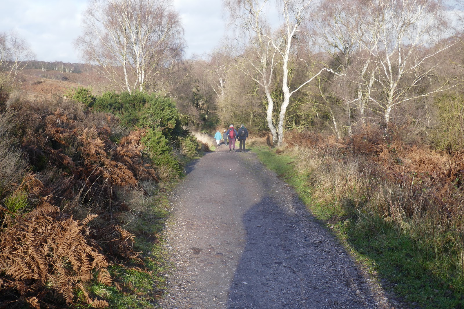
Past the boulder we descended, as so often before, into the Sherbrook Valley. It is a pleasant, gentle descent through gorse covered heathland.

Down into the Sherbrook Valley

At the bottom we turned right to follow the brook. I can find no record of the Sher Brook being used to power mills, but there are odd pools which look mill-related to my amateur’s eye.

(Mill?) pool on the Sher Brook

A kilometre later we joined the Heart of England Way where it crosses the brook and followed it as it turned right towards Flints Corner and joined Marquis’s Drive.

>Here Marquis’s Drive is a tarmac road. We paused for coffee on a roadside bench and watched a large group of walkers go by. The road later becomes a footpath and descends towards the railway and the A460 Hednesford Road. On the descent we re-passed the group; three people can sit on a bench, twenty must make do with the wet ground.


Marquis's Drive, Cannock Chase (with the large party on and round the bend)

I have occasionally wondered why Marquis’s Drive (usually referred to as Marquis Drive) is so called. I have a plausible (if unproven) answer.

Marquis's Drive ends (or starts) at Beaudesert Park. The Estate and House (now a ruin on the edge of the Chase) was granted to Henry Paget, the 1st Baron Paget, in 1546. The family collected titles and the 10th Baron, another Henry Paget (b 1768), was also Earl of Uxbridge and Baronet of Plas Newydd, Anglesey. He was Wellington's Second in Command at Waterloo where he famously mislaid his leg. As a reward he was created 1st Marquess of Anglesey because another title was just what he really needed.

The Marquesses of Anglesey lived at Beaudesert, with Plas Newydd (now owned by the National Trust, we visited 2018) as a second house, for six generations. The 5th Marquess (1875-1905) was an interesting character whose extravagances led to bankruptcy. and his early death, after which the titles passed to his cousin, Charles. He tried to keep Beaudesert going but eventually bowed to the inevitable and sold the estate making a gift of 120 acres to Cannock Chase District in 1920 and a further (unspecified) gift 'to the people of Staffordshire' in 1938. Marquis’s Drive is presumably named after him. (Marquess is the preferred spelling, but Marquis is a common variant.)

Charles Paget, 6th Marquess of Anglesey (also 7th Earl of Uxbridge, 15th Baron Paget and 9th Baronet Plas Newydd)
(portrait by Rex Whistler, 1937)

At the bottom we crossed the railway. Last time I was there this involved opening a gate, looking both ways and scuttling across, now an elaborate footbridge has been constructed.

Footbridge over the railway, Marquis's Drive, Cannock Chase

We still had to cross the A460 on foot – which was always more dangerous than the railway.

The crossing used to be down there, by the white house

Marquis’s Drive continues up the other side. I have previously moaned about the long slog up Miflins Valley, which runs parallel a little to the north, but the climb up Marquis’s Drive seemed much pleasanter. Eventually the Miflins Valley path turns and runs into Marquis’s Drive. We made a navigation error at that point last year; this year there was no error and it was hard to see how we ever made one.

Nearing the top of Stile Cop and the end of Marquis's Drive
Somehow a much gentler and pleasanter ascent than Miflins Valley

Marquis’s Drive ends at the top of Stile Cop, more a ridge than a hill, despite its name. As usual Lee’s car had earlier been positioned in a Stile Cop Road car park, but instead of walking to it and driving to the Swan with Two Necks in Longdon we crossed the road and plunged down a muddy forestry trail towards the Horsepasture Pools, thus entering Beaudesert Old Park and venturing further east than any previous Chip Walk*.

After some slipping and sliding the path improved and I was strolling along, talking to Lee when we suddenly realised Francis was missing. Turning, we saw him striding down towards us. It is unlike Francis to lag at the back (that’s my job) and he watered a tree just before Stile Cop, so why was he behind? As he came closer we could see that his left arm and leg were covered in mud, closer still we observed that both knees had been torn out of his trousers. The slimy sludge had claimed a victim, his knees were red, his trousers ruined and he was caked in mud, but his dignity had suffered the most.

A mud-bespattered Francis catches up, Beaudesert Old Park

After a brief scrape down, we continued to the largest of the Horsepasture Pools.

The largest of the Horsepasture Pools, Beaudesert Old Park, Cannock Chase

The map showed a network of forestry roads, and to climb Hare Hill to Upper Longdon we should turn left, second right and then bear right. In fact, we followed the single path straight into the village. The mismatch between map and ground was a warning.

The Chetwynd Arms in Upper Longdon…

Approaching the Chetwynd Arms, Upper Longdon

…then became the third pub (and the second ‘Chetwynd Arms’) to host the walk’s traditional fish and chips. The ‘small’ portion lived up to its description, which made the afternoon walk easier. A couple of pints from the excellent Three Tuns brewery in Bishop’s Castle did not, perhaps, help that cause but were much enjoyed.

Fish and Chips at the Chetwynd Arms, Upper Longdon

It was only 5km back to Lee’s car on Stile Cop Road. We started by retracing our steps to the Horsepasture Pools.

Back down to the Horsepasture Pools, Beaudesert Old Park, Cannock Chase

The track that should have taken us from our earlier route up towards Startley Lane did not exist (we had been warned!) so we turned late, followed a barely discernible path in roughly the right direction and emerged on Startley Lane only a little to the east of our intended point.

We could then have walked down the road to a signed right-of-way, but Lee was scornful of that approach. He suggested that if we cut through the forest we would pick up the path in 150m or so. His argument won the day, but once you go off-piste you tend to stay off-piste.

Once you go off-piste you tend to stay that way, Beaudesert Old Park

We never did pick up the proper path, but we did find a muddy track which eventually became an unmarked farm road and deposited us on The Slade only 50m from the sign marking the intended path.

Lee hides in the rhododendrons to avoid the mud

Back on track we followed the road until a bridle way led us behind some farm building where we found a signed path, for once exactly where the map said it was, heading steeply up Stile Cop. I had an attack of cramp at the bottom – my penance for trying to keep up with two much fitter walkers - but after a brief pause for stretching I found the steep gradient aided recovery.

A steep climb at the base of Stile Cop

The path at the top was barely visible, so we followed our best guess....

At the top the path was barely visible, Stile Cop

...until reaching a crossing of trails where we should have gone straight over – through impenetrable gorse bushes. Being only 500m from the car we zigged and then zagged....

Is this a zig or a zag?

...following any passable track (and there were many on the ground, though none on the map) that seemed to lead in the right direction. This approach was surprisingly effective and we reached the car at 3 o’clock.

As if by magic the car park appears, Stile Cop

It had been a short walk, as these things go, but long enough for me and a good test for my plantar tendons, which have taken well over six months to recover but seem to have got there.

home I stopped at a red light and a girl crossed the road wearing trousers ripped exactly liked a pair I had seen earlier. I emailed Francis to tell him he had inadvertently arrived at the cutting edge of fashion but he said had had already thrown the trousers away. Apparently, some people just do not want to be a fashion icon.

*Oh dear it seems we took a similar route in 2011, walking to Upper Longdon and driving to the Swan with Two Necks, so this is not entirely true.

The Annual Fish and Chip Walks

The Nth: Cannock Chase in Snow and Ice (Dec 2010)
The (N + 1)th: Cannock Chase a Little Warmer (Dec 2011)
The (N + 2)th: Cannock Chase in Torrential Rain (Dec 2012)
The (N + 3)th: Cannock Chase in Winter Sunshine (Jan 2014)
The (N + 4)th: Cannock Chase Through Fresh Eyes (Dec 2014)
The (N + 5)th: Cannock Case, Dismal, Dismal, Dismal (Dec 2015)
The (N + 6)th: Cannock Chase Mild and Dry - So Much Better (Dec 2016)
The (N + 7)th: Cannock Chase, Venturing Further East (Jan 2018)
The (N + 8)th: Cannock Chase, Wind and Rain (Dec 2018)
The (N + 9)th: Cannock Chase, Freda's Grave at Last (Dec 2019)
The (N + 10)th: Cannock Chase in the Time of Covid (Dec 2020)
The (N + 11)th: Cannock Chase, Tussocks(Dec 2021)
Dec 2020 - no walk
The (N + 12)th: Cannock Chase, Shifting Tectonic Plates (Dec 2023)