Friday, 21 April 2023

Madeira (4): Eira do Serrado and Câmara de Lobos

A Deep Valley, a Glass of Madeira and a Seaside Village

A Brief Introduction


Portugal
Madeira
Madeira, as you probably know, is a Portuguese Island in the Atlantic, 1,000km south west of Lisbon and 700km west of the Moroccan coast. It measures 50km from east to west, 20km from north to south and rises to 1,861m (6,106 ft) at Pico Ruivo. It has 250,000 permanent inhabitants, half of whom live in the capital, Funchal. Our hotel was in the Lido district, 40 minutes' walk along the coast west of central Funchal.

Madeira

A Disappointing Morning

We had booked and paid for an afternoon excursion, our plan for the morning was to make it up as we went along, but even that simple strategy went wrong. Madeira’s benign climate makes it a 12-month tourist destination, but the high mountains can at any time snag a passing cloud, thus ensuring sufficient rainfall to keep the island green, the gardens blooming and the crops healthy. Without rain Madeira would be like the nearby Islas Desertas, unsettled and without visitors, but like every other tourist we had selfishly hoped the rain would fall on somebody else’s week, not ours

It cleared up sufficiently for us to venture out for coffee and cake – a regular pleasure on the mainland, but not one that had hitherto fitted our schedule here. The café, a few steps down from the road and festooned with patrons’ wet weather clothing, felt like a damp basement. The coffee was fine, but our pasteis de nata fell well short of the Algarve's best – or was that just the weather?

We wiled away the rest of the morning with a little shopping and sheltering. By lunchtime the rain had gone and we sat outside the café opposite out hotel and drank a beer. A little later we were at the bus stop waiting to be picked up for our excursion,

Miradouro Pico dos Barcelos

Our driver filled his minibus with people waiting expectantly by other bus stops or outside hotels and drove us towards Santo António, a parish in the northwest corner of Funchal. From the coast the land rises steadily to the foot of the mountains, but just below Santo Antonio a ridge rises to some 335m (1165ft). The summit offers 360° views, so the municipality has thoughtfully constructed a miradouro (viewpoint).

Westward we looked across Funchal and the Atlantic …

Funchal and the Atlantic Ocean from Pico dos Barcelos

… while to the north the city climbs the first wave of the interior uplands.

Looking north from the Picos dos Bracelos

Also looking north, but down from the ridge, is Santo António itself. The typical local church is where a young man who would bring fame to Santo António took his first communion. Cristiano Ronaldo, arguably the greatest living Madeiran, was born nearby on the 5th of February 1985. Almost universally regarded as the best European footballer of his generation, his career included spells at Sporting Lisbon, Manchester United, Real Madrid and Juventus, and over 200 international appearances Portugal.

Santo António

Miradouro Eira do Serrado

The rather more dramatic Miradouro Eira do Serrado is 10 km north, the drive into the mountains normally taking around 20 mins, but not today. Just outside the city the road runs through a narrow defile which was blocked by a broken-down digger. Rather than wait for the rescue equipment our driver headed back into town to find an alternative route.

Before reaching the countryside, we passed the stadium of Maritimo, Funchal’s leading football club. Founded in 1910 they started playing in the Portuguese League in 1973, first reached the top tier in 1977 and have remained there since 1985. [Update: they would lose that status at the end on 2022-23 season and now play in the second tier alongside Nacional, Funchal’s other professional club.]

Three hundred metres further on we passed the ground – stadium would be an overstatement – of Andorinha Football Club where Cristiano Ronaldo’s played as a child. He moved to Nacional juniors aged 10 and two years later was signed by Sporting Lisbon after a three-day trial. He made his debut for the first team at 17, and at 18 moved to Manchester United.

The route took the best part of an hour’s driving, leaving Funchal and entered the municipality of Câmara de Lobos.

The Miradoura at 1095m (3,600 ft) looks down on the isolated village of Curral das Freiras sitting on a step on the lip of the valley. When first settled the land belonged to João Gonçalves Zarco one of the island's co-discoverers, but at first only the desperate tried to wring a living from this isolated valley.
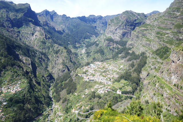
Curral das Freieras

More organised agriculture arrived in 1462 when Zarco granted the land to João Ferreira and his wife Branca Dias. In 1480 their grand-daughter sold the land to Zarco’s son, João Gonçalves da Câmara, who donated it to the Convento of Santa Clara. The valley was the perfect place for nuns to do whatever nuns do without interruption and the settlement previously known as Curral de Sierra – corral of the mountains – became Curral das Freiras – corral of the nuns.

Much work was done terracing the valley sides below the village…

Terracing opposite central Curral das Freiras

….and eventually it was linked to Funchal by a tunnel.

The modern road linked to Funchal by tunnel

Wild flowers are abundant on the valley side including one known as Pride of Madeira. I know little about flowers but these look like lupins to me, maybe they are.

Pride of Madeira

Barbeito Madeira

Our descent was aided by the newly cleared and reopened defile. From there we veered further west, away from the city, though there was plenty of development in the ‘countryside.’

Above the village of Câmara de Lobos we took a minor road to the Barbeito winery.

Barbeito

The company was founded in 1946 by Mário Barbeito de Vasconcelos and remains a family company. They specialise in making Madeira wine, the fortified sweet wine, oxidised by heat before bottling. I described the process for making Madeira when we visited Blandy’s in Funchal and will not repeat myself here though I will note that ‘normal; wines are made on Madeira too, but they are labelled Madeirense not Madeira..

Stainless steel tanks, Barbeito Winery

The heyday of Maderia was the late 18th and early 19th centuries. At one time there 70 British owned Madeira houses, and many others besides, but their best export market were the British colonies in North America and then the new-forged United States of America. The second half of the 19th century Madeira was cursed with diseases of vines, first odium, then phylloxera and as the American market struggled to recover along came Prohibition. There are now 8 Madeira producers, Blandy’s (AKA The Madeira Wine Company) are the only surviving British family firm.

p
Barbeito

Barbeito started when the Madeira market looked doomed, but they survived. In 1991 they dropped out of the bulk trade feeling they were too small, and concentrated on quality. A brave decision at the time, but Madeira’s recovery could only come from concentrating on quality.
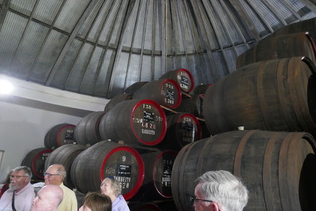
Barbeito barrels

The showed us round their facility, gave us a lecture and finally a glass of wine, or more precisely, Rainwater. When barrels stood on the quay awaiting export some were, inevitably, rained on. It was thought this produced a lighter wine and the Rainwater style of Madeira was born, It is made deliberately these days (the meteorological method was always more in the imagination than on the palate) and was always popular in the United States. Barbeito’s Rainwater was light, fresh, clean and medium dry, like a softer version of Blandy’s sercial. I liked it very much, it would make an excellent aperitif and would be a better companion for cheese than the heavier sweeter wines. We were told they are having some success in reviving the American liking for Rainwater, and I would not object if some of it came our way.

Câmara de Lobos

Leaving the good people of Barbeito, we drove down into Câmara de Lobos, the main settlement of the eponymous municipality. Câmara de Lobos was given city status in 1996, but the centre looks more like a village surrounded by a banana-packed amphitheatre.

Câmara de Lobos - all those bananas are watching, you know

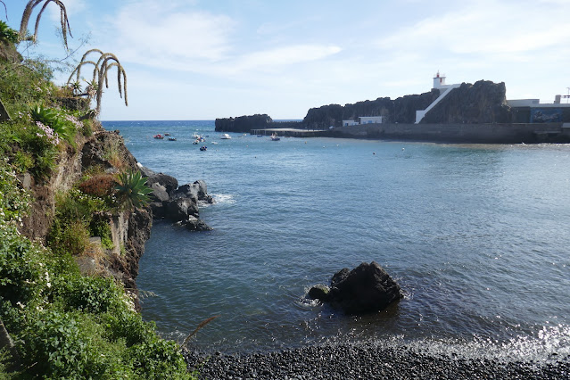
When João Gonçalves Zarco first landed here he also saw the amphitheatre, enhanced by the two rocky peninsulas….

Eastern side of the Harbour, Câmara de Lobos

…that create the natural harbour.

Western side of the harbour, Câmara de Lobos

The harbour and beach were full sea mammals, sounding and looking like a debating chamber (câmara in Portuguese). Soon the settlement was known as Câmara de Lobos – Chamber of Wolves - but Madeira has no wolves. There is a story that Zarco’s sailors could not tell the seals’ barking from the howling of wolves, but I cannot believe that. The ‘sea mammals’ were probably monk seals, they have gone now (they dislike humans) but there is a colony on the Islas Desertas, the only one outside the Mediterranean. But the Portuguese for seal is selo. I looked up Portuguese Wikipedia and it used the phrase lobos marinhos and Wikipedia’s translate facility renders this as sea lion. So that settles it, except that Google translate insists that sea lion is leão marinho (lit. sea lion) while lobo marinho means sea wolf. I might be overthinking this, so let’s settle for Parliament of Seals and hope they do a better job than the non-seals we elect.

There are few boats out in the harbour, they are all on what might elsewhere be the car park.

Parked boats, Câmara de Lobos

The actual car park is further back. I rarely, if ever, photograph car parks, but cropping out the vehicles as far as possible…

Bougainvillea, Câmara de Lobos

…leaves the spectacular bougainvillea on the rear wall.

Câmara de Lobos is a pleasant little place, but we only had time for a quick look round. It made me wonder why it is the focus of so many tours.

Winston Churchill paused in Madeira in 1899 as a young army officer on his way to the Boer War. He returned as a tourist in 1949 and 1950 after his wartime stint as prime minster and again in 1956 after his second stint, staying at Reid’s Hotel. He enjoyed painting, and frequently visited Câmara de Lobos on painting trips. This is its USP, and the reason why British tourist are always taken here.

Winston Churchill Paining in Câmara de Lobos
I do not know if this photo is still in copyright, if it my apologies to the copyright holder

I admit to a frisson of excitement when (pre-blog) I climbed ancient steps in Egypt’s Siwa Oasis to the room where the oracle told Alexander the Great that he was the son of Zeus. Sadly, standing where Winston Churchill once painted a picture does give the same feeling. Even less exciting is the information that Margaret and Dennis Thatcher spent their honeymoon in the Savoy Hotel, just down the road from Reid’s. Both hotels feature in the post Madeira(2).

Thursday, 20 April 2023

Madeira (3): Funchal to Santana

A Journey Round Madeira's Eastern Tip and Back over the Mountains

Brief Intro


Portugal
Madeira
Madeira, as you probably know, is a Portuguese Island in the Atlantic, 1,000km south west of Lisbon and 700km west of the Moroccan coast. It measures 50km from east to west, 20km from north to south and rises to 1,861m (6,106 ft) at Pico Ruivo. It has 250,000 permanent inhabitants, half of whom live in the capital, Funchal. Our hotel was in the Lido district, 40 minutes' walk along the coast west of central Funchal.

Madeira

Madeira Municipalities
For today we had booked a tour which would take us round the eastern end of the island and back across the mountainous centre. Madeira is an Autonomous Region of Portugal and the island is divided into 10 municipalities for local government purposes. Our trip would take us through the four westernmost municipalities.

A minibus picked us from our hotel and, after a couple more pickups, slid round the back of Funchal, following the dual carriageway through a series of tunnels until we reached the coast road. Madeira (1) and (2) were Funchal based, so this journey really starts in the municipality of Santa Cruz.

Santa Cruz

Cristiano Ronaldo International Airport


There is enough space between the mountains and the sea for continual development all the way from Funchal to Machico. Fitting in an airport presented some difficulties, but in 1964 a bunch of optimists laid out a runway across a small headland near Santa Cruz, some 14km from Funchal. The original runway was notoriously short and was extended in the 1980s and again in 2000 and now crosses the coast road on pillars and continues over the sea.

Madeira Aiprort. The runway crosses the coast road and heads out to sea.

The runway may now be ample, but Ronaldo Cristiano Imternational Airport (as it has been known since 2017) is still regarded as one of Europe’s most difficult airports. Arrivals from the north (the vast majority) cross the Ponta de São Lourenço, Madeira’s straggling rocky eastern tail, 10km from the airport. The prevailing wind usually requires a 180° turn and the topography demands a swift drop onto the runway. This is a breezy spot and winds swirl and bounce from the hillsides. Occasionally they close the airport and passengers are diverted to the Canaries.

Incoming having crossed the Ponta de São Lourenço. Wheels are lowered, so perhaps this plane won't be making the 180 degree turn 

Machico

Machico Town


Pausing on the cliffs north of the airport for the photo above, we could also look down on the town of Machico, home to some 11,000 people. Another 11,000 live within the wider Machico Municipality.

Reputedly, it was on Machico’s beach of grey-black volcanic sand that João Gonçalves Zarco and Tristão Vaz Teixeira came ashore on the 1st of July 1419 and claimed for Portugal the hitherto inhabited island they had named Madeira. The photo also shows part of a small beach of golden sand protected by a breakwater. The sand is imported from North Africa to encourage tourists.

Machico

Machico grew and prospered, mainly from cultivating sugar cane. In 1440 Prince Henry (the Navigator) created João Gonçalves Zarco and his descendants hereditary Capitanos of Machico. (He made Tristão Vaz Teixeira hereditary Capitano of what is now Funchal. Both became rich from their discovery and lived into their 80s, which was rare at the time).

The parish church of Nossa Senhora da Conceição was built while Zarco was Capitano. His statue outside the church was unveiled in 1934 and is by Francisco Franco (the Funchal born sculptor, not the Spanish dictator).

Captin Zarco outside the Nossa Senhora da Conceição

Caniçal and the Ponta de São Lourenço

We drove round Caniçal, the next town along the coast, and continued as far down the Ponta de São Lourenço as the road goes. A 2.5km hiking trail starts at the car park and finishes where the mainland stops. The last 2.5k are on two separate islands, the inner and larger Ilhéu da Cevada is 10m away from the mainland at one end and and 100m from the smaller and outer, Ilhéu da Farol (Lighthouse Islet) at the other.

Sadly, we had no time to walk out to the end but there are viewpoints all around. I am unsure if this windswept spot on the north coast is the Miradouro de Abismo marked on the map, but it fits the name.

Miradoura de Abismo (possibly)

From here you can look east out to sea…

Looking east along the north coast of the Ponta de São Lourenço

…or west where the rest of Madeira lies.

Looking west - into the abismo?

Elsewhere there are views south and west over Caniçal and Machico. Caniçal may be a small town, but is a major port; cruise ships dock at Funchal but most cargo comes through Caniçal.

Caniçal and Machico in the distance

Porto da Cruz: Engenhos da Norte

From the somewhat unworldly surroundings of Madeira’s ‘tail’ we drove west along the north coast to Porto da Cruz. Apparently, the discoverers of the harbour erected a large cross, so they could find it again. For reasons I will come to later, this seems an unlikely story.

The Machico municipality grew rich by growing sugar cane. There are many things you can do with sugar like making a cake or sweetening your coffee, but sugar is bad for your teeth, so it is much better to turn it into rum. The Engenhos de Norte (Northern Mills) distillery has been doing this since 1927.

Our driver stopped in the small car park and left us to look round while he organised a tasting. The distillery occupies an unassuming rectangular building at the sea end of the main street, its chimney, almost hidden against the higher ground of the headland beyond.

Inside we saw the usual barrels, but did not find the stills.

Barrels, Engenhos da Norte

Engenhos de Norte is a rare distillery still powered by steam…

Working steam engine, Engenhos da Norte

… generated by burning sugar cane waste.

Moving the fuel, Engenhos da Norte

Having seen what there was to see we rejoined the driver who was carying a tray crammed with tiny plastic glasses of rum.

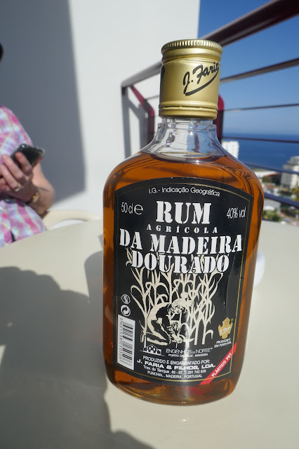
The distillery produces several different rums, some white for making poncha (see Madeira: Eating and Drinking) and brown rums of various ages. They also produce rums (picture below) sold under other labels. The rum we tasted, like the bottle below, was minimally aged brown rum.

Madeira rum

Rum, as I have belatedly come to understand, is as complex and many layered as whisky. I very much like Havana 7-year-old, a Cuban heavyweight, and the light, fruity Mount Gay Eclipse from Barbados - though from different ends of the style spectrum they are both quality products. When travelling in India I often drink Chennai distilled Old Monk, A thin and aggressive spirit whose main attraction is the lack of an alternative. Engenhos da Norte is full bodied enough to fit in the middle of the style spectrum, and is well enough made not to be confused with Old Monk. It proved ideal for our night caps on the balcony.

Porto da Cruz: A Stroll Round the Headland

The driver gave a rendezvous time and suggested we might like a walk around the headland. Despite its name there is no port at Porto da Cruz, though there is a small bay with a black sand beach protected by a headland on one side and the vast bulk of Penha da Águia (Eagle Rock) on the other. Why, I wondered, would someone construct a cross to indicate an insignificant harbour, already marked by a rock half a kilometre high?

Penha de Águia, Porto da Cruz

We strolled in gentle sunshine following a path that crossed the headland before the end and then headed back towards the village with views eastwards along the coast….

Lynne, Porto da Cruz

….the magic of zoom revealing a sea arch standing off the Ponta de São Lourenço.

Looking east from Porto da Cruz

We spent some time admiring the view and had to walk more swiftly to complete the circuit on time. Somehow, we missed the fish shaped swimming pool clearly shown on aerial photographs. Returning to the village we discovered it had more streets than we had realised and with the clock ticking on, a little anxious navigation was required to get us back to the minibus almost on time. We apologised, but it hardly mattered, another bus had parked in front of ours and we were going nowhere.

Santana

Faial


The parking problem was soon resolved and we drove over the ridge behind Penha da Águia, leaving Machico Municipality and entering Santana. Faial is the name of the next village along the coast and the local name for the shrub Myrica faya, native to the Azores, Canaries and Madeira.

Our visit to Faial was brief, and, perversely, I will start at the end – we had the best view of the village as we left it over the ridge towards the town of Santana. It shows Faial overlooked by Penha da Águia sitting on two plateaux divided by a small river.

Faial and the Penha de Águia

Most of the village is on the western plateau (closer to the camera). At the tip of the headland is the Miradouro do Guindaste, where two short walkways stretch out from the cliff, 26m above the sea.

The Miradouro do Guindaste

It was somebody’s great idea, no doubt, but the result was, I thought, disappointing. Looking down through the fibreglass floor was not particularly dramatic, while the view looking outwards was fine, but by local standards moderate at best.

View from the Miradouro do Guindaste

Santana Town

Santana is a small town with some 3,500 inhabitants just inland from the coast. It is the principal settlement of its largely mountainous municipality.

Santana

Lunch here was an optional extra on the tour, but as we prefer to eat later, we had declined the offer. We wondered if we might be the only ones, but discovered that exactly two people had booked lunch. Santana offers several alternatives and we enjoyed a beer and a steak sandwich at A Espiga.

With a little time to look around, we strolled down to the 16th century church.

Parish Church of Santana

The rear is surprisingly plain…

Church of Santana

…while the front is determinedly baroque. The screen has representations of Santa Ana and San Joaquin, while behind is a gilded altarpiece.

Screen and altarpiece, Church of Santana

Santana also has a fine collection of traditional Madeira thatched houses. The style dates from the first settlements on the island when wood was plentiful and straw was available as soon as settlers started growing cereals.

Traditional Madeira thatched cottage

Houses with the traditional shape and colour schemes are common in Santana, but traditional interiors are rare. Typically, they had a loft where the family slept, and a simple living room and storage cellar below. To protect the thatch from fire, there was usually a small outdoor kitchen. Today they often used as shops for tourist souvenirs.

Thatched cottage in the modern tradition: selling stuff to tourists 

A Brief Levada Walk

Driving south from Santana we were impressed by the fruit trees; pomegranate, papaya, custard apple, mango and more. The hilly topography rarely allows enough space for a commercial orchard, but there was plenty of fruit for the locals. Most of these would be considered tropical fruit, though Sanatana is almost 10° north of the Tropic of Cancer.

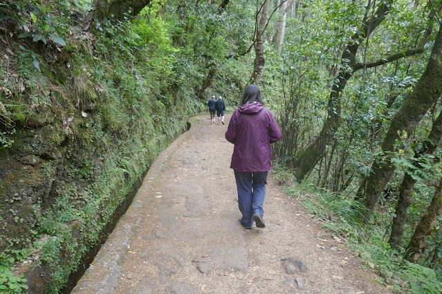
As we rose the temperature dropped and there was a threat of rain. We stopped at Ribeiro Frio for a brief Levada Walk. The rain in Madeira falls on the mountains and levadas (Portuguese levar: to carry) are aqueducts, some many kilometres long, built through and around the mountains to bring water from where it falls to where it is needed.

Lynne sets off on a Levada walk

Those who laboured to build them probably never imagined that walking beside the levadas would one day become a leisure time activity.

Levada Walk

Levada walks vary from the simple to the challenging, but none can be readily adapted to circular walks, so an industry has grown up transporting walking groups to starting points and picking them up later from somewhere else.

View from Levada Walk

We had time only for a brief, flat, out and back, but even in that there was a surprising amount of variety.

Levada Walk

Pico de Arieiro and Back to Funchal

From Ribeira Frio we took a side road towards the Pico de Ariero, at 1,818m (just shy of 6,00ft) Madeira’s third highest peak, and the highest that can be reached by road. Unfortunately, as we climbed, the road disappeared into a mist that became denser and denser with every metre gained. Apparently, the views from the top are dramatic, and there is a miradouro a short walk from the car park, but visibility was so poor we could not even see that we were in a car park. ‘It happens,’ said the driver with a shrug.

We descended back into Funchal, where the sky was clear and we could see two cruise liners in the dock.

Descending into Funchal

Back at sea level it was a little overcast but warm enough, and in the evening we dined outdoors (see Madeira: Eating and Drinking). After dinner we sat on our balcony with a tot of rum and watched yet another cruise ship arrive.

Another cruise liner arrives in Funchal